- A persistent low-pressure system brought extensive rainfall across wide areas of the Northern Territory and Queensland.
- Flooding occurred in remote communities, presenting a challenge for emergency services.
From late February to early March 2023, a persistent and slow-moving monsoon low produced extensive rainfall over wide areas of northern Australia, including the Northern Territory and north-west Queensland. While the low-pressure system was much weaker than a tropical cyclone, barely dropping below 1000 hPa (hectopascals), its long-lived and slow-moving nature led to spectacular accumulated rainfall totals over several days (Figure 1).
The monsoon low initially formed around the 24th February over north-western Western Australia, situated within a prominent monsoon trough (Figure 2). From here it strengthened and slowly tracked south-eastwards into the Northern Territory, where widespread weekly rainfall values of more than 200 mm were recorded.
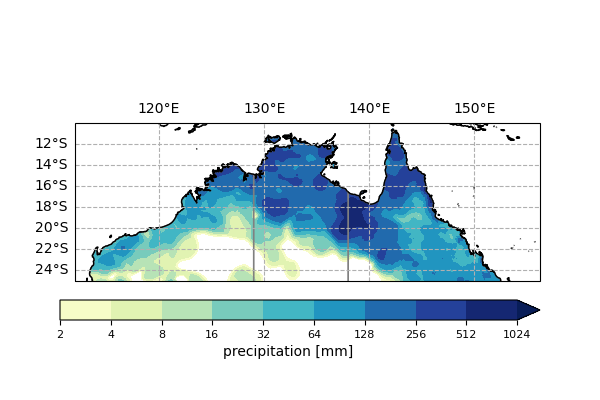
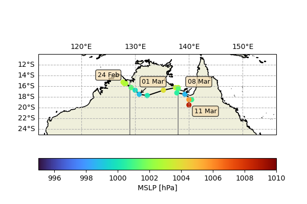
From the start of March, the low weakened slightly, continuing its slow eastward movement. A second pulse of development began on 3rd March as it moved towards the Queensland border. In the 24 hours to 8th March, Century Mine (located north of Mount Isa) received a record 315 mm of rainfall.
The low began to weaken from 8th March. In its final stages, a midlatitude trough (a band of low pressure) from southern Australia interacted with the weak low-pressure system, bringing moderate rainfall to central and southeast Queensland.
The remote location of the flooding provided a considerable logistical challenge to emergency services supporting isolated communities. In the Northern Territory, people in three Indigenous communities, Kalkarindji, Daguragu and Pigeon Hole, were evacuated and relocated to Darwin. They were temporarily housed in shelters until they could safely return to their community up to three months later.
The Northern Territory flooding impacted transport routes as floodwaters cut off rail access to South Australia and increased the reliance on one road to connect the states. This resulted in widespread food shortages and some grocery stores flying in food, placing further strain on affected communities, such as Lajamanu, which were trapped by the waters.
Flooding in northern Queensland also resulted in major transport disruption to the supply of essential food products. Re-routing food transport increased costs for suppliers and transport time, with some regions waiting for over a week for food supplies to arrive.
Persistent monsoon lows like these are uncommon but not unheard of in Australia. We have seen numerous recent events of a similar nature, such as the 2019 northern Queensland floods and ex-Tropical Cyclone Ellie in early 2023.
Centre researchers are working to understand how these slow-moving and high-impact weather systems work and what role they may have in the future. While there are some theoretical grounds to believe they will worsen in a warmer climate, it is still an active topic of research today.
Research contacts:
Corey Robinson, corey.robinson@monash.edu Camille Justine Mora, c.mora@unsw.edu.au Professor Michael Reeder, michael.reeder@monash.edu