Numerical models of the weather and climate system are key research tools in gaining a deeper understanding of the mechanisms that generate climate extremes. They are also our primary tool in assessing how these extremes may be affected as our planet warms. The Modelling research program at the ARC Centre of Excellence for Climate Extremes is therefore an underpinning and enabling activity that develops improved simulations, tools and procedures for use in all research programs across the Centre.

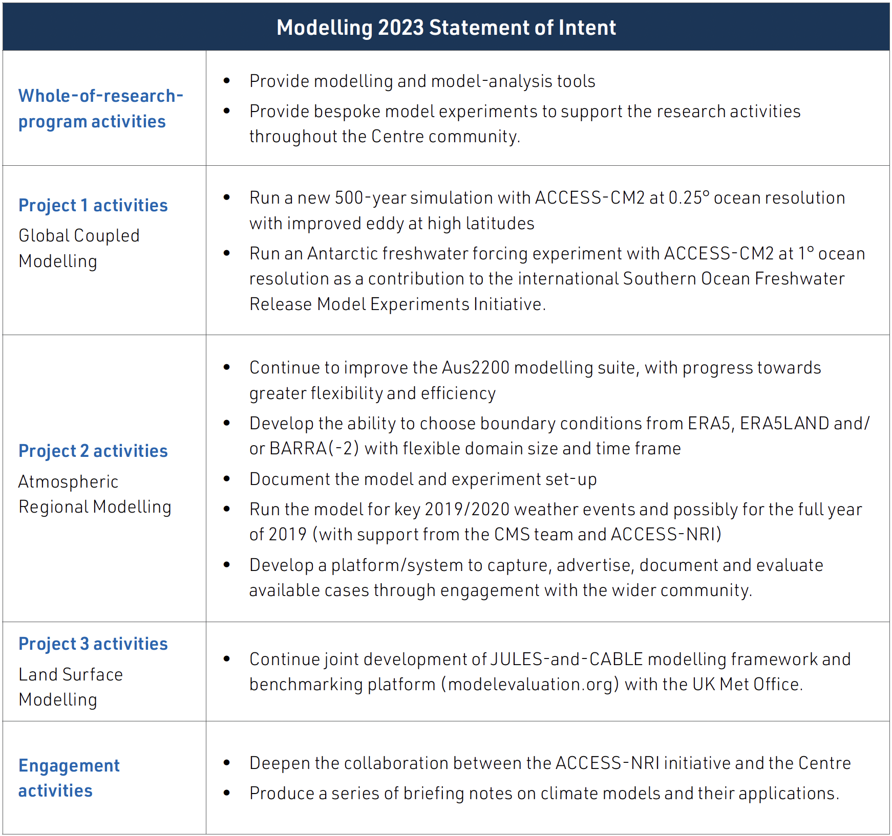
PROJECT 1
Global Coupled Modelling
in collaboration with our partners at CSIRO, the Modelling program has completed a 500-year present-day simulation of the Australian Community Climate and Earth System Simulator–Coupled Model 2 (ACCESS-CM2) climate model with an ocean component at a higher lateral resolution (0.25°) that allows eddies to be resolved across most of the globe. Work continues towards improving the eddy parameterization at high latitudes, where eddies are poorly resolved. Wilma Huneke commenced in a postdoctoral researcher role in 2022 to evaluate the new model and to investigate the effect of ocean resolution on decadal climate variability.
PROJECT 2
Regional Atmospheric Modelling
In a project led by Dr Hooman Ayat, the ACCESS regional model has been run with the most up-to-date configurations over the Australian region, with approximately two-kilometre horizontal grid spacing (the Aus2200 project). Extensive testing has been performed to optimise the model configuration and setup. Initial simulations for the 2019/2020 megafire event have also been completed and evaluated. This is a real technical achievement.
Dr Ayat has been using the simulations to explore the weather conditions that made the 2020 New Year’s Eve fires in south-eastern Victoria so extreme. In particular, Dr Ayat has investigated the source of the extremely dry but localised air ahead of the approaching cold front, which is thought to have been an important contributor to the severity of the conditions. A paper on this is planned for 2023.
PROJECT 3
Land-surface Modelling
The merging of new science undertaken by the Centre into the newest version of CABLE has continued. At the end of 2022 this version of CABLE was being evaluated against multiple sets of observations. In parallel, research has been published using key elements of this new version, which is focused on how groundwater influences the expression of drought and heatwaves in high-resolution regional climate simulations. This work demonstrated that groundwater could cool temperature extremes by up to 3 °C at the surface, which was not unexpected. However, because these simulations were conducted using a coupled land surface-atmospheric modelling system, the impact on temperature extremes could be evaluated within the atmosphere. Results showed changes of up to 1 °C through the atmospheric boundary layer. These results point to an important influence of groundwater on heatwave intensity, implying the necessity of considering groundwater dynamics in climate models in future heatwave predictions.
Mu, M., Pitman, A.J., De Kauwe, M.G., Ukkola, A.M., Ge, J., 2022. How do groundwater dynamics influence heatwaves in southeast Australia? Weather and Climate Extremes 37, 100479. https://doi.org/10.1016/j.wace.2022.100479
RESEARCH SNAPSHOT
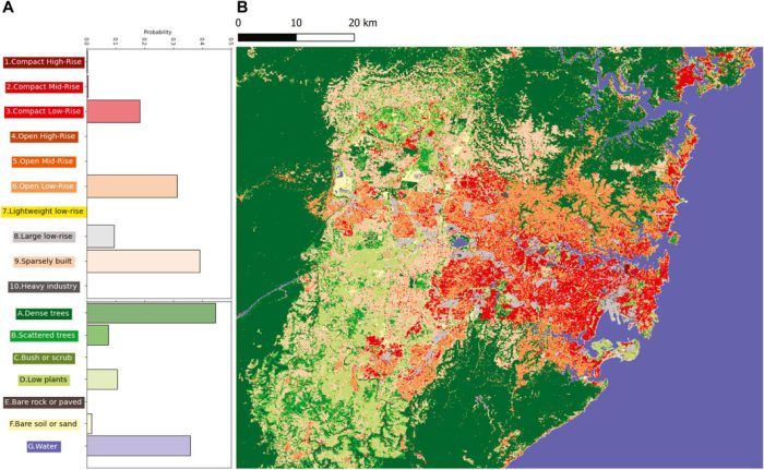
In a world first, Centre postdoctoral researcher Dr Mat Lipson and colleagues partnered with Australian companies AURIN and Geoscape to transform the way cities can be integrated in weather and climate models. The research was enabled by a new generation of sub-metre urban morphology data sets covering entire continents and powered by machine learning, satellite imagery and remote sensing. From these new data sets they could, for the first time, configure our urban climate models across large geographical extents with unparalleled accuracy, from the ‘bottom-up’. AURIN and Geoscape are the developers of the only continental-scale building-resolving data set available in the world, which includes the shape and height of every building in Australia larger than nine square metres (a small bedroom), as well as the land cover of all Australian urban areas at two-metre resolution.
From this valuable Geoscape data the collaborators derived new data sets for Sydney and Melbourne, with 25 parameters used to configure slab, canyon or block-array urban land surface models. We negotiated with Geoscape to make the derived Sydney data openly available at 300-metre resolution, which makes it suitable for high-resolution urban climate modelling.
This bottom-up approach is in stark contrast to the top-down or class-based methods traditionally used to configure urban models since the beginning of the field 50 years ago. The authors compare the latest top-down methods (for example, the 10-class Local Climate Zones) with their bottom-up approach, and they provide tables of adjusted parameter values that are more appropriate for modelling, using classes in Australian cities. They discuss the future of top-down versus bottom-up methods of configuring urban models and predict that bottom-up will come to replace top-down as consistent building-resolving data sets become more widely available globally in coming years.
Lipson, M.J., Nazarian, N., Hart, M.A., Nice, K.A., Conroy, B., 2022. A transformation in city-descriptive input data for urban climate models. Frontiers in Environmental Science 10, 866398. https://doi.org/10.3389/fenvs.2022.866398
RESEARCH SNAPSHOT
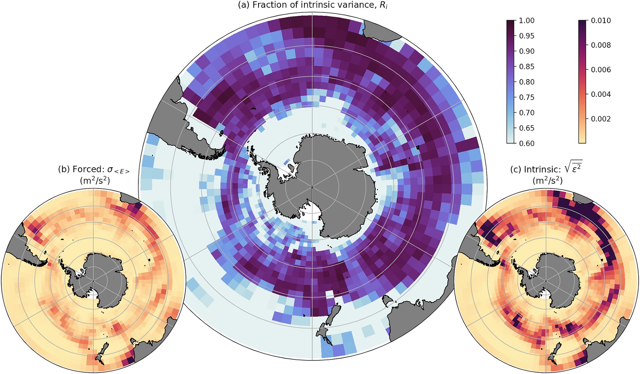
The Southern Ocean is the most turbulent part of the world’s oceans. This turbulence, often referred to as eddies, is critical to the evolution of the Southern Ocean under climate change. But it’s hard to get information about these eddies, because they occur on small scales in a large ocean basin that is poorly observed. In addition, the observational record is quite short, which makes it more difficult to use these observations to study what controls variations of these eddies. For this reason, Centre Chief Investigator Professor Andy Hogg and colleagues used an eddy-permitting ocean model and ran it 50 times with the same prescribed surface winds but slightly different initial states.
The chaotic nature of the turbulent ocean means that these model runs exhibit different evolutions. So the simulations were used to study which eddy processes occur as a consequence of the chaotic nature of turbulence and which are forced by the external factors that are common to all model runs, such as the winds. The collaborators concluded that monthly-to-interannual fluctuations of the Southern Ocean eddy field are dominated by chaotic processes, but that the forced variability responds to wind on particular time scales that are controlled by the mechanisms that generate ocean turbulence.
Hogg, A.McC., Penduff, T., Close, S.E., Dewar, W.K., Constantinou, N.C., Martínez-Moreno, J., 2022. Circumpolar variations in the chaotic nature of Southern Ocean eddy dynamics. Journal of Geophysical Research: Oceans 127, e2022JC018440. https://doi.org/10.1029/2022JC018440
ARC Centre of Excellence for Climate Extremes – Annual Report 2023
From the Chair of the Advisory Board
Climate Science Leaders of the Future
Weather and Climate Interactions Research Program
Attribution and Risk Research Program
Ocean Extremes Research Program
Computational Modelling Systems
Governance, Management and our Commitment to Equity, Diversity and Inclusion