Written by Laure Poncet and Jarrad Rowe
Last month, Western Australia experienced three successive heatwaves which smashed heat records and brought energy demand levels to a record high.
Perth broke its record for the most days hotter than 40°C, while Carnarvon Airport hit a record high of 49.9°C, surpassing the old record by more than two degrees.
All three heatwaves were driven by the same meteorological pattern. Let’s take a closer look at what happened during that period.
Hot desert air in play
The first heatwave occurred between January 31 and February 3, the second heatwave between February 8 and 12 and the third heatwave between February 14 and 21.
During all three heatwave events, high-pressure systems were sitting over the Great Australian Bight. Because winds flow counterclockwise around high-pressure systems, this resulted in the transport of hot arid air from central Australia to the western and southwestern parts of Western Australia, also known as the Midwest-Wheatbelt regions (Figure 1).
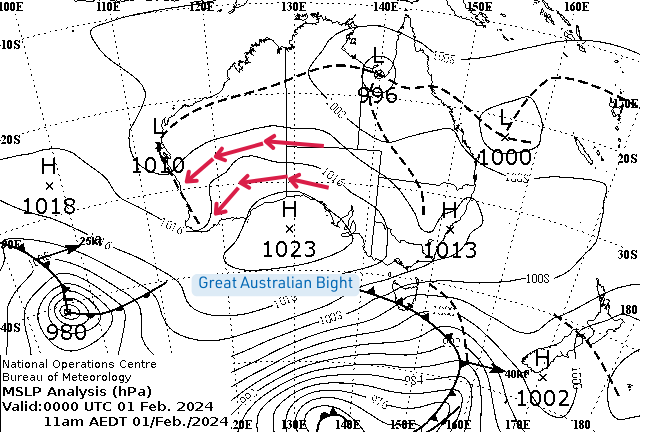
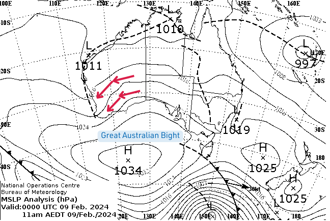
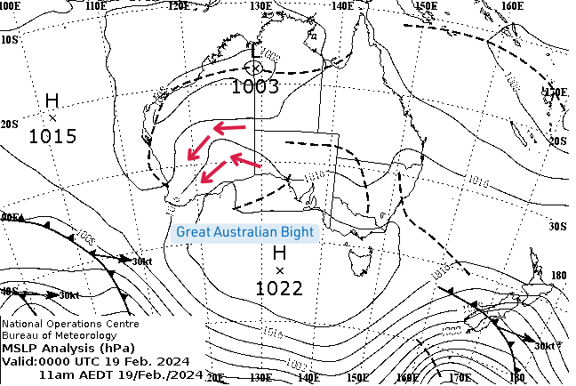
Figure 1: Mean sea level pressure (MSLP) on February 1 (first heatwave), February 9 (second heatwave) and February 19 (third heatwave). Source: Bureau of Meteorology
Jarrad Rowe, heatwave expert at the ARC Centre of Excellence for Climate Extremes, said: “All three events were typical Western Australian heatwaves, with stationary high-pressure systems in the Great Australian Bight which kept transporting hot air from the central Australian desert into the Western Australian regions.”
Additionally, there was a heat trough along the west coast of Western Australia during each event.
Rowe said: “The troughs prevented the sea breeze from coming on shore and cooling down the coastal regions.”
“In all three events, the troughs also strengthened the easterly flow and channeled the hot air southward along the west coast of Western Australia. This explains why central and southern regions of the state were more impacted by the heat than northern regions.”
First heatwave: 31 January – 3 February
The first heatwave started with a trough sitting on the coast on January 31.
“During this event, daytime temperatures were 8 to 14°C above average in the far south of the state and in the Midwest-Wheatbelt regions,” said Rowe.
On February 1, Badgingarra recorded 44.3°C, while Mullewa hit 45.6°C on February 2.
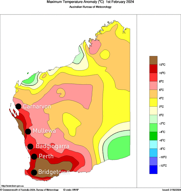
A few stations also broke their February temperature records on those days. Bridgetown recorded 42.6°C, surpassing its previous record by 1.2°C. Other records include 43.3°C in Rocky Gully and 43.4°C in Wagin.
The first heatwave ended on February 3 with a cold front passing over the Great Australian Bight.
“The cold front pushed the high-pressure system out of the Great Australian Bight and shifted the heat trough inland. This allowed the sea breeze to return, resulting in cooler conditions,” said Rowe.
Second heatwave: 8-12 February
Another heatwave event affected large parts of Western Australia between February 8 and 12.
“This second heatwave was probably the weakest of the three events, no temperature records were broken,” said Rowe.
Temperatures remained however in the high range, with much of western Australia experiencing maximum temperatures above 42°C during that period (Figure 3).
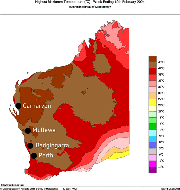
Between February 8 and 10, Perth Airport had three consecutive days with daily maximum temperatures above 40°C. Similarly, Carnarvon Airport experienced two consecutive days above 40°C between February 9 and 10.
On February 11, temperatures approached 45°C in Mullewa and Badgingarra, before returning close to the February average with the end of the heatwave event on February 12.
Third heatwave: 14 – 21 February
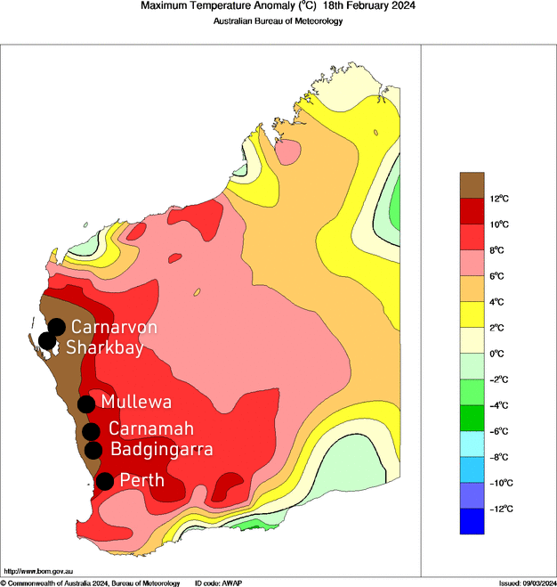
Much of Western Australia experienced extremely hot conditions during the third heatwave event that occurred between February 14 and 21.
“Most of the towns we’ve looked at experienced temperatures 12°C or more above their maximum February average during this heatwave event.”
Between February 18 and 19, Carnamah, Badgingarra and Mullewa broke their maximum temperature records for the month of February, reaching highs of 48.0, 46.7 and 47.1°C, respectively.
Additionally, a few stations broke their annual record maximum temperature during that period. Carnarvon Airport reached a record high of 49.9°C, while Shark Bay Airport hit 49.8°C.
“Typically, you’re looking at maximum temperatures in the mid-thirties on average for those regions, so temperatures in the high forties were quite extreme for that period,” said Rowe.
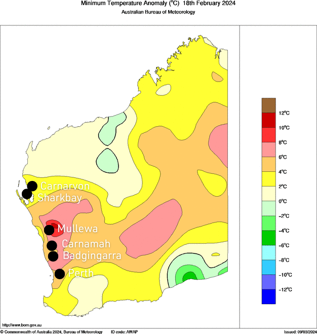
It was also unusually warm at night, with minimum temperatures up to 12°C above the February average (Figure 5). This was due to the trough inhibiting the sea breeze from cooling the regions during that time.
“The definition of a heatwave requires the maximum and minimum temperatures to be above average for at least three consecutive days,” said Rowe.
“That was the case here, temperatures remained quite high at night and residents had no relief from the hot daytime conditions.”
Mullewa and Badgingarra both hit 30°C overnight on the 18th and 19th respectively, while temperatures dipped to just 27.5°C in Perth.
Similar to the first heatwave, the third heatwave finally broke on the 21st with the passage of a cold front over Western Australia which pushed the high-pressure system out of the Great Australian Bight and shifted the trough inland.
What were the impacts of the successive heatwaves?
Extremely hot conditions smashed electricity demand levels, with the top six operational demand peaks ever recorded in the state’s main grid all occurring between January 31 and February 19.
On February 18, electricity demand soared to a record high of 4200 Megawatt forcing the Australian Energy Market Operator to declare an “emergency operating state.”
Rowe said: “It was a record-high electricity usage. Power companies were prepared for these heatwaves. However, more frequent heatwaves increase the risk of blackouts for the region.”
Additionally, extreme heat combined with dry and gusty easterly winds resulted in several fires burning across Western Australia during the second heatwave event, with the largest one occurring near Albany.
Did climate change play a role?
The three February heatwaves were caused by stationary high-pressure systems. It is difficult to say whether climate change played a role and further studies on these specific events would be necessary.
In general, however, climate scientists are confident that heatwaves in Australia will become more intense, longer and more frequent because of climate change.
“With rising temperatures, the probability of having more extreme or hot days increases and the chance of that actually happening in succession increases as well,” said Rowe.
Although Western Australians are well adapted to hot weather, these events raise concerns due to their negative impacts on the energy sector, agriculture and human health.
The ARC Centre of Excellence for Climate Extremes aims to better understand heatwaves and is researching how physical processes impact these events, contributing to better forecasts.