Kimberley J. Reid – Originally published in Australian Geographer.
Few meteorological terms have caused such debate as Atmospheric Rivers (ARs). ARs were proposed in 1992, but a formal definition for ARs was only developed in 2015 following the observational campaigns of the 2000s that led to a deeper physical understanding. ARs can cause extreme rainfall, flooding, landslides, damaging winds, glacier melt, and even polar heatwaves. Despite their well-documented global impacts, there has been relatively little research on this phenomenon in Australia. Compound events involving ARs led to the devastating 2021 and 2022 flooding in eastern Australia. The media were drawn to the metaphor of a ‘river in sky’ but the term has not been embraced by our national weather service, and some scientists still question their existence. This essay explores the controversy of the name Atmospheric River and highlights what could be achieved if we focused less on the name and more on the science.
The El Niño part of the El Niño-Southern Oscillation was coined by Peruvian fishermen in the 1600s who noticed that the periodic warm waters off the coast of South America typically peaked in December. Given the proximity to Christmas, they referred to this current of water as El Niño de Navidad in reference to Jesus Christ (Philander 1990). In modern times, this has been shortened to El Niño. The Indian Ocean Dipole, on the other hand, is so named because it is a mode of variability with two poles that occurs in the Indian Ocean – far less poetic. Some names are arguably designed to be attention grabbing, while others are more technical. Few meteorological terms could be described as having been met with ‘everything from dismissive disdain for its oversimplification, to wonder at its intuitive nature’ (Ralph et al. 2020). This essay will explore the frustrations and joy of being on the receiving end of both the disdain and wonder as a PhD student undertaking the first thesis on Atmospheric Rivers (ARs) in Australia, and what could be achieved if we focus on research efforts on this topic rather than the name.
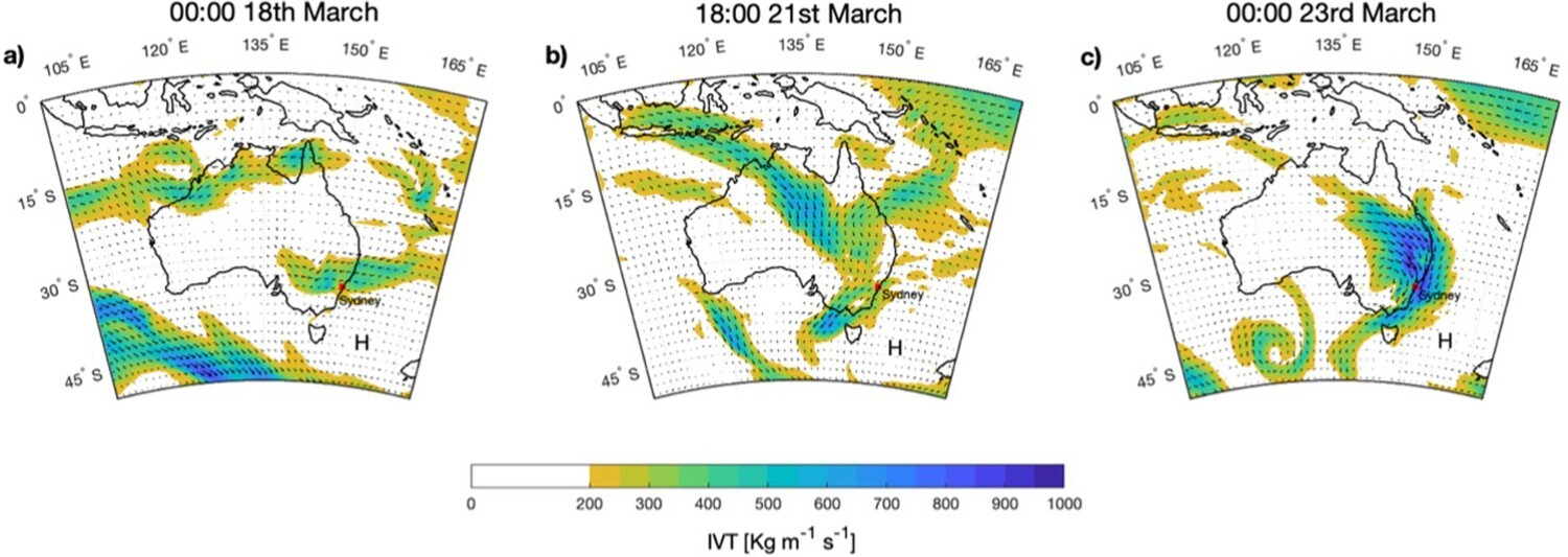
During 2021 and 2022, eastern Australia sustained multiple intense Atmospheric Rivers that contributed to widespread flooding, extensive damage, and loss of life and livelihoods (Reid et al. 2021; Figure 2). The first three months of 2022 were the wettest start to the year for Sydney since records began and images of the 14.4 m flood peak in the town of Lismore dominated the news cycle for weeks.
The concept of a ‘river in the sky’ delivering the torrential rain captivated the media.
However, the ‘river in the sky’ analogy appeared to pave the way for non-scientific metaphors such as this first sentence that appeared in WA Today (Brookes 2022): Experts warn Perth could be walloped with rain bombs described as ‘tsunamis from the sky’ as climate change intensifies weather systems known as atmospheric rivers. Neither rain bombs nor tsunamis from the sky are real meteorological terms for the phenomena described in the article, but to be fair to the journalist, scientists can be inconsistent with the terms we use.
Atmospheric Rivers, originally named Tropospheric Rivers, first appeared in the scientific literature in 1992 (Newell et al. 1992). These long, narrow regions of enhanced meridional water vapour transport were suggested as a mechanism to explain the carbon monoxide problem. That is, why high concentrations of carbon monoxide were observed in regions far from a potential source and not explained by the prevailing winds. The phenomenon was a called a river because the magnitude of moisture transport was comparable to the Amazon River (∼165 × 106 kg s−1). Although the name did not appear until 1992, the concept of low altitude, large-scale streamers of moisture transport had been discussed before by James and Anderson (1984).
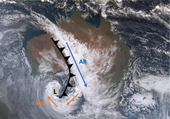
The term Atmospheric River was initially contentious and there was confusion between the concepts of ARs and Warm Conveyor Belts (WCBs). The WCB is a narrow, continuous band of ascending low-level moisture from the warm sector in an extratropical cyclone. WCBs are often recognisable on satellite images as the comma-shaped cloud associated with an extratropical cyclone (Figure 1). WCBs are associated with thunderstorms and rainfall (Browning 1971).
Some scientists did not like the term Atmospheric River (e.g. Bao et al. 2006) because it implied that all the moisture originated from a source (i.e. the (sub)tropics) and flowed to the poles when in reality a significant amount of the moisture in an AR comes from local convergence (Dacre et al. 2015). Knippertz and Martin (2007) even used the phrase Moisture Conveyor Belt because it fit with the existing conveyor belt model of extratropical cyclones.
To settle the confusion among scientists, experts in ARs and WCBs gathered to develop a clear definition for ARs in June 2015 at the Scripps Institution of Oceanography in California, USA. They concluded that an Atmospheric River is: ‘A long, narrow, and transient corridor of strong horizontal water vapour transport that is typically associated with a low-level jet stream ahead of the cold front of an extratropical cyclone’.
Despite the bumpy beginning, Atmospheric Rivers are now generally accepted in the global meteorological community.
For example, the joint project, AR-Recon, involves multiple US universities, government research agencies, and the US military, in collaboration with the European Centre for Medium-Range Weather Forecasting (ECMWF). They send aircraft over ARs off the Californian coast to gather data with the aim of improving observations and the predictability of these weather systems (Ralph et al. 2014). This reconnaissance program is planned to be conducted over Europe too. The Californian Department of Water Resources have developed a Forecast-Informed Reservoir Operations Program to incorporate AR forecasts into their water release strategies to improve dam management, and approximately 140 people attended the fourth International Atmospheric River Conference in 2022.
However, as our understanding of ARs grew globally, it became clear that this definition did not encapsulate all regional cases of the phenomena, especially on the western side of the Pacific Ocean. While winter is the peak AR season in North America, multiple independent studies have found that ARs are most common in the warmer seasons in East Asia (Kamae et al. 2017; Pan and Lu 2020), New Zealand (Prince et al. 2021) and Australia (Reid et al. 2022), indicating that we cannot simply assume ARs will behave the same over Asia and Oceania as they do elsewhere and therefore a regional understanding is important.
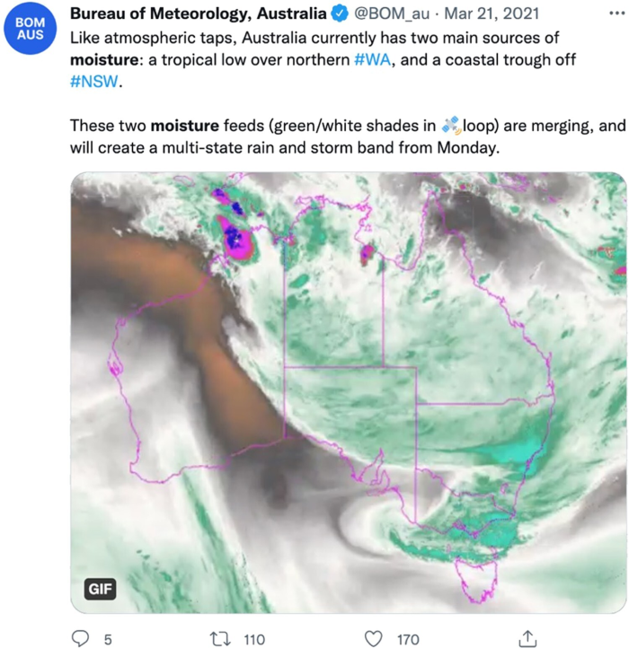
This is the context in which we turn our attention to Australia. The Bureau of Meteorology’s Special Climate Statement on the February to March 2022 extreme rainfall and flooding did not mention the phrase ‘Atmospheric River’ in the entire report (The Bureau of Meteorology 2022). The meteorology of the event was instead described as: A blocking high pressure system near New Zealand, combined with a series of low-pressure systems, fed a large volume of tropical air over eastern Australia. There is nothing scientifically wrong with this description, but it is striking that the official report on an event that involved a strong AR made no mention of ARs. This is not an isolated occurrence. In March 2021, the AR-induced rainfall event (Figure 2) was described by the Bureau of Meteorology as ‘like atmospheric taps’ and ‘moisture feeds’ (Figure 3). This is despite the term ‘Atmospheric River’ existing in the literature for 30-years, and despite the recent collaboration between the Bureau of Meteorology and Chinese Meteorological Agency to investigate ARs in the Australia-Asia region (Ye et al. 2020). It is unclear why there has been resistance to the term Atmospheric River.
It is not only the Bureau of Meteorology who appears to have an aversion to the term. As the first person in Australia to complete a PhD thesis on Atmospheric Rivers, I experienced the resistance to the concept first-hand. I felt colleagues took me more seriously if I described my PhD work in the context of large-scale regions of enhanced water vapour transport instead of Atmospheric Rivers despite referring to the same thing. I spent the first year of the PhD frustrated after every presentation I gave because, without fail, I would always be questioned on the existence of Atmospheric Rivers by senior scientists. The interrogation of new ideas is fundamental to scientific progress, and I assure you, reader, I have no intention of stifling debate nor declaring AR science settled. What was tedious was that these conversations had already been had elsewhere years earlier (Ralph et al. 2020). Decades of scientific literature in high quality journals had already been written on the topic. I was not inventing a new concept, but merely expanding our regional understanding of ARs to include Australia. The name used to describe strong moisture transport could certainly be argued as being somewhat trivial, however it is inconceivable that anyone could be simultaneously up to date with the literature in this area, engaged with international forecasting and research agencies on the topic, and not use the widely accepted name. It is not the name itself that is important, but the avoidance of the term is a symptom of deeper concerns.
We are lagging the rest of the world. This is problematic because ARs can cause extreme weather events in Australia.
They have been found to cause significantly enhanced melting and associated discharge over Australia’s snowpack (Mcgowan et al. 2020) and are associated with around 30% of the top 100 heaviest rainfall days in southeast Australia (Reid et al. 2022). The recent floods of March 2021 and February–March 2022, were associated with ARs making landfall over eastern Australia. In addition, the AR associated flooding in February–March 2022 in southern Queensland and Northern New South Wales was not well forecast. At just a 24-hour lead-time, most of the extreme rainfall appeared offshore in the ECMWF high-resolution model, which is usually regarded as the best weather forecasting model. At a lead-time of two weeks, global models indicated that rainfall over these regions were likely to be below average … rather than record breaking (ECMWF 2022). Additionally, reconnaissance efforts over the eastern Pacific have shown that enhanced dropsonde observations during strong AR events can improve precipitation forecasts at 24-hour lead-times (Lord et al. 2023). There has been one observational study of an AR in Australia (Rauber et al. 2020) and we have the potential to grow and become a regional leader in this area. Improved regional understanding of ARs is important for improving our preparedness and resilience to climate extremes in Australia, and targeted observational campaigns could potentially improve short-term forecasts of extreme events (Lavers et al. 2020).
Between the initial submission of this essay and a later edit, the Bureau of Meteorology and Commonwealth Scientific and Industrial Research Organisation released their State of the Climate report for 2022 (CSIRO & Bureau of Meteorology 2022), which did include a mention of ARs. The widespread flooding of 2022 may be the impetus needed to spur more research in Australia on the mechanisms that move vast amounts of water vapour through the atmosphere. Perhaps the tide is turning, and atmospheric rivers will be seen as more than just a buzzword from the 90s.
Atmospheric Rivers are large-scale regions of enhanced water vapour transport that are associated with extreme weather events globally. While the concept of a river in the sky captivated the media, it polarised scientists. Following years of debate, a formal definition was constructed for the American Meteorological Society’s weather glossary. Research efforts globally exploded in recent years, but Australia is behind in our regional understanding of ARs. This is a concern due to the role of ARs in extreme rainfall over eastern Australia. Despite decades of established literature, there is resistance to accept the term Atmospheric River within Australia, which undoubtedly slows research efforts. I cannot help but wonder: if El Niño was discovered today, would the name be accepted? Probably not. It is neither a scientific term nor descriptive of the actual phenomenon, but that has not hindered research efforts on the topic. The name itself does not matter, but the avoidance of it does. While scientific debate is important and healthy, we must be careful not to let nomenclature become the centre of the debate, and ultimately delay progress in our understanding of phenomena.
Kimberley J. Reid (2023) Say my name: the polarising name of atmospheric rivers, Australian Geographer, DOI: 10.1080/00049182.2023.2199465