Weather systems are the building blocks of the climate, as it is the aggregate of these weather systems that defines the climate. Of course, the connection is not one way, since the frequency and amplitude of various weather systems are themselves modulated by climate.
The Weather and Climate Interactions research program investigates climate, and especially climate extremes, through a weather lens. In this pursuit, our work focuses on the physical mechanisms responsible for extreme weather in the tropics and extratropics – and the effect of climate change on these mechanisms. Understanding how the weather changes as the world warms, and especially how extreme weather changes, is an important part of how climate change affects people, the economy and the environment.
The Weather and Climate Interactions research program was added to the Centre’s research portfolio last year and is now in full swing. We have appointed our full complement of postdoctoral research associates, we have a strong cohort of graduate students, and we are making significant contributions to the science of weather and climate extremes.
PROJECT 1
Fronts are perhaps the only weather systems implicated in heat, wind and precipitation extremes. To illustrate this point, consider the following: the most catastrophic fires in recent history in southern Australia have been associated with extreme but shallow dry cold fronts that form along the southern coastline; Melbourne’s record maximum temperature preceded the passage of the extreme cold front on Black Saturday; and frontal systems commonly provide the uplift needed to produce extreme precipitation. Our research into extratropical extremes is guided by the overarching question:
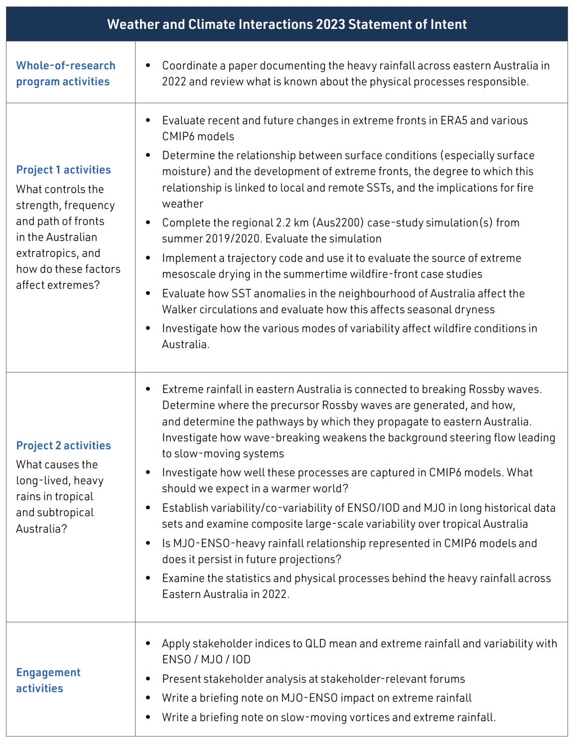
What controls the strength, frequency and path of fronts in the Australian extratropics, and how do these factors affect extremes?
In a project led by Dr Hooman Ayat, a version of the Australian Community Climate Earth System Science model has been configured and run over the Australian region with approximately two-kilometre horizontal grid spacing. This is a real technical achievement. It is also a real scientific achievement, as Dr Ayat has used the model to explore the weather conditions that made the 2020 New Year’s Eve fires in south-eastern Victoria so extreme. In particular, Dr Ayat has investigated the source of the extremely dry but localised air ahead of the approaching cold front, which is thought to have been an important contributor to the severity of the conditions.
In a project led by Dr Malcolm King, we investigated strong cold fronts in Australian station data, as defined by daily maximum temperatures decreasing by at least 10°C between two consecutive days. These strong cold fronts occur most often during spring and summer and are more common along the southern regions of Australia. Although no widespread trend in the frequency of strong fronts was detected during the 110-plus-year record, relationships between increased strong-front frequency and El Niño, positive Indian Ocean Dipole and negative Southern Annular Mode patterns were found for many stations in the south-eastern parts of Australia. This result suggests a link between dryer conditions and increased occurrence of strong fronts. Exploring this link more fully is one of the future directions of this project.
PROJECT 2
Tropical lows are among the most important rain-bearing weather systems in the northern half of the continent. For example, in north-western Australia, around half of all summertime rainfall is associated with them. Moreover, tropical lows are commonly implicated in rainfall extremes. These considerations motivate our second overarching research question:
What causes the long-lived, heavy rains in tropical and subtropical Australia?
This research question could hardly have been more timely! In the last year, the eastern seaboard of Australia has been inundated. Research led by Dr Michael Barnes has shown that this kind of inundation is due to slow-moving vortices in the upper atmosphere. The rainfall is copious because these vortices linger over eastern Australia and force air upward on their eastern flank. In 2022 these vortices inextricably linked to a surface anticyclone over the Tasman Sea, which directed moist easterlies onshore. Rossby wave breaking near the end of the jet stream is the physical process responsible for slow-moving upper-level vortices and the associated surface weather pattern. Our research emphasises that the upper levels of the atmosphere is the key to understanding and predicting the kind of heavy rain and inundation we’ve experienced in 2022.
Another important contribution to our science is that led by Dr Dawn Yang. It has been widely publicised that 2022 was a La Niña year. Dr Yang’s work is also extremely timely, as it is focused on how the rainfall associated with the various phases of the Madden-Julian Oscillation (MJO) change between El Niño and La Niña conditions. In comparison to El Niño conditions, the rainfall maximum propagates as a focused region from west to east across northern Australia. One result of particular relevance is that the rain is highly focused on the eastern seaboard in the later stages (MJO Phases 6 and 7).
RESEARCH SNAPSHOT
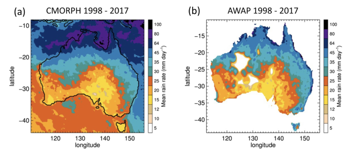
Although previous studies of extreme precipitation have focused mainly on extreme daily rainfall, brief but heavy rain can cause flash flooding, severe damage and dangerous conditions. These sub-daily extremes are often confined to small areas that can be missed by rain gauge networks or satellites, and they are very far from being resolved by climate models. In this study, we find a robust positive trend of at least 20% per decade in sub-hourly extreme rainfall near Sydney, Australia, over 20 years, despite no evidence of trends at hourly or daily scales. This trend is seen consistently in storms tracked using multiple independent ground radars, is consistent with rain-gauge data and does not appear to be associated with known natural variations. This finding suggests that sub-hourly rainfall extremes may be increasing substantially faster than those on more widely reported time scales.
Ayat, H., Evans, J.P., Sherwood, S.C., Soderholm, J., 2022. Intensification of sub-hourly heavy rainfall. Science 378, 655–659. https://doi.org/10.1126/science.abn8657
RESEARCH SNAPSHOT
This study reports on the atmospheric conditions that are necessary to produce rainfall extremes in three different regions of Australia. It finds that it takes two to tango. In all regions, the ingredients are very high moisture content and strong upward vertical motion. Either of them alone is not sufficient for extreme rainfall. This result highlights the important interplay between the dynamics and thermodynamics of weather systems in making rainfall extremes. In other words, how and where weather systems force ascent, along with how and where they tap into moist air, are crucial. Understanding how extreme rainfall will change with climate change therefore requires us to understand how both moisture and vertical motion change as the planet warms.
White, B.A., Jakob, C., Reeder, M.J., 2022. Fundamental Ingredients of Australian Rainfall Extremes. Journal of Geophysical Research: Atmospheres 127, e2021JD036076. https://doi.org/10.1029/2021JD036076
ARC Centre of Excellence for Climate Extremes – Annual Report 2023
From the Chair of the Advisory Board
Climate Science Leaders of the Future
Weather and Climate Interactions Research Program
Attribution and Risk Research Program
Ocean Extremes Research Program
Computational Modelling Systems
Governance, Management and our Commitment to Equity, Diversity and Inclusion