Prologue
The Australian Outback is a whole different universe that I got to experience on a winter day in June 2013. From Brisbane, Queensland on the east coast of the Land Down Under, I hitched hiked and volunteered my way through the iconic Australian ‘Wild West’. This 800km ride west was memorable: driving up the Great Dividing Range, stopping for R.M. Williams retail sales in Toowoomba, passing through the Western Downs, Queensland’s best cropping land, refueling in Miles, grocery shopping in Roma and spending 6 weeks herding sheep on a motorbike across the vast Macfarlane station in Tambo, was a unique opportunity to experience first-hand the many challenges of life in the country.
Importance of Rangelands
The biological landscape of Australia has been shaped by the traditional ways of life of the Aboriginal people over the millennia. The rangeland biome in particular consists of perennial drought-resistant grass species interspersed with some shrubs and low-tree overstorey species that constitute extensive downs in parts of inland Queensland (QLD).
The Mitchell Grass Downs (MGD), Astrebla grassland overstorey, are a highly palatable native species that have sustained sheep and cattle production in part of semi-arid QLD, providing for entire families across generations since the European settlement of Australia in the late 18th century (Sattler & Glanznig 2006). The general ecology of the region has been significantly modified across large areas, and a marked decline in the condition of the grasslands has been observed over the last decades, raising great concern over the natural rangeland resources, hallmark of QLD’s identity (Phelps, Orr & Houston 2007).
Western QLD Grazing System
Western QLD in particular was opened for pastoralism in the late 1860s with most suitable lands grazed under private ownership by the late 1880s. Severe and extended droughts in the late 1890s through to 1902 were the first of eight major degradation episodes from across Australia’s grazed rangelands that have initiated a search for more reliable water supplies.
As drilling the depth of the Great Artesian Basin for water had become common by 1920s, a second degradation episode resulted in government legislation for regulation of carrying capacity that created smaller properties from the large private company holdings that had dominated ownership for the first 40-50 years. Wool production from Merino sheep run on family-operated properties dominated the pastoral industry with a peak of sheep numbers and production in the 1950s (Phelps 2012, p. 16) (McKeon 2004b, pp. 110-35).
Economics of Rangelands deterioration
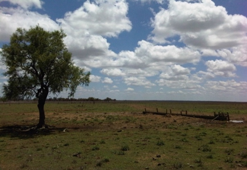
Macfarlane station, located near the service town of Tambo in central-western QLD, is a 10,000 ha cattle and sheep grazing property operated by Andrew Martin, a 4th generation pastoralist. Alongside a small team of experienced shepherds and very enthusiastic kelpie and border collie dogs, I rode a 250cc motorbike across different paddocks, day end, six days a week, mustering the tens of thousands straying sheep that he owns. I experienced first-hand the many challenges that arise in merino sheep breeding, prime lamb livestock production and beef farming, understood the extent of the Mitchell grass dieback and devastating economic effects it has had on the local community.
In his life time, Andrew – whom everybody calls Marto – witnessed 4 extended droughts of at least 24-month duration in Tambo with the ‘1998-1904’ Federation drought and the 2000-2009 ‘Millennium’ drought said to have been the worst on record. Poor pasture response and wide-scale death of Mitchell grass tussocks has occurred historically in line with these periods of extended.
Reports expressing concern, over the extreme stock losses induced, can be found in historical literature. It has been estimated that more than 100 million sheep died in the eight severe droughts that have affected the Australian pastoral industry since the 1880s, with detrimental effects for the regional economy (McKeon 2004b, pp. 19-20).
Nearly 5000 field assessments and surveys of the productivity of Mitchell grass pastures were undertaken from the mid to late 2005. Major research publications and reports, result of a joint collaborative effort from both the QLD Department of Agriculture, Fisheries and Forestry (Phelps, Orr & Houston 2007) and the Commonwealth Scientific and Industrial Research Organisation (McIvor 2010), have helped assess the ecological requirements and devise recovery strategies.
Mitchell Grassland basic ecology
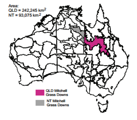
The Mitchell Grass Downs (MGD) bioregion extends across central QLD into the Northern Territory (see Figure 2). While much of Australia’s continental interior is covered by grassland, the native western rangelands can be climatically described as sub-temperate.
MGD are dynamic ecosystems where species compositions and richness change seasonally in response to soil chemistry, landform, rainfall and temperature (World Meteorological Organization 2010). The management of tillers during and after droughts is therefore of key importance.
One main component of rangeland degradation is desertification. Desertification is the diminution or destruction of the biological potential of rangeland, thereby the capacity of the pasture to respond to rain and produce useful forage (Bastin, GN & Ludwig 2006; Phelps 2012).
When patchy rain in the Tambo-Blackall district suggested that the decade-long Millennium drought ended in the summer 2009, most Mitchell grass tussocks throughout the west produced a low-vigour response at best (Phelps et al. 2007, pp. 1-7).
Mitchell grass seedlings germinate best over summer. For germination to occur (1-2/m2 of seedlings), it needs a sufficient reserve of seed in the soil, temperatures above 10°C and 50-100mm of rain. In general, fewer than 10% of seedlings survive to become established tussocks.
For seedlings to become tussocks, follow-up rains of at least 100-150mmin, reduced competition from annual grasses and forbs and minimal grazing pressure as well are needed for to develop extensive root systems, albeit survive through their first dry season.
Once established, young Mitchell grass tussocks benefit from early wet-season spelling (resting period) for 4-6 weeks over the next 2-3 summers. Tussocks of at least 5cm diameter at the base are more likely to survive the next drought (Phelps et al. 2007, p. 10).
Drought can further damage weakened pasture and intensify wildfire. Most of the very poor condition country in the open downs land types is due to the invasion of woody weed (e.g. prickly Gidyea).
The manifestation of land and pasture degradation on rangelands, including at Macfarlane, are the loss of ‘desirable’ perennial species such as the Mitchell grass, and resulting increase in soil erosion, soil structural decline and infestation of woody weeds (McKeon 2004b, p. 17).
In the intermediate short-term management response to pasture deterioration, the aforementioned resting period and benchmarking safe stocking rates are two important tools that Marto uses to increase grass species richness and health.
Climate change projections for the region, however, represent a significant challenge to livestock production and grazing system on the long term.
Extreme ENSO and climate change induced impacts
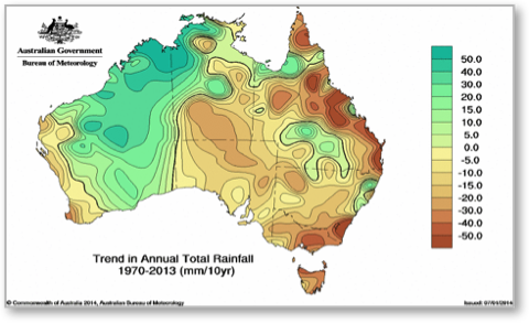
Droughts are inevitable in Australia’s rangelands (see Figure 4) and the issue of climate change has been prevalent in the media since early 2007, often in the context of increased rainfall variability and increased frequency of drought across the Mitchell grass country.
Some of the major climate forcings affecting climatic variability in Australia’s rangelands are the El Nino – Southern Oscillation (ENSO), the Inter-decal Pacific Oscillation (IPO) and the Pacific Decal Oscillation (PDO).
In most cases the sequence of dry years, ranging from two to eight years, has revealed and/or contributed further to the degradation process that was already in train (McKeon 2004b, pp. 17-8)
Both ENSO and IPO/PDO were shown to be associated with the large year-to-year variation in rangeland rainfall and pasture growth in the region (Clewett & Clarkson 2007). Climate forecast systems based on the southern oscillation index (SOI) or sea surface temperatures (SSTs) have been developed in order to fine tune seasonal rainfall forecasting in the region.
As an example, three-monthly forecasts based on SSTs can be found on the National Climate Centre of the Bureau of Meteorology (BoM)’s website. The Queensland Centre for Climate Applications (QCCA) also provide historical probability analysis based on SOI phases (McKeon 2004b, p. 20).
The 2015-2016 El Niño was one of the strongest of the 26 recorded since the 1970s with substantial increase in the SSTs, and associated devastating effects on Australia’s world-famous Great Barrier Reef lagoon. Unlike the 1997-1998 El Niño that followed a neutral year in 1996-1997, the 2015-2016 El Niño is following a La Niña colder conditions that spanned over the eastern parts of QLD in 2014.
The observed impacts of ENSO confirmed its influence on the regional weather patterns, resulting with 2 severe category cyclones spanning westwards from the Pacific Ocean region, over a period of just 18 months. The various components of this system operating at different timescales however add to the complexity of understanding the extreme wet and drought sequences experience throughout the state over the past decades.
With Landsat TM images becoming available since the beginning of the 1980s (Chuvieco Salinero, Emilio & Huete, Alfredo 2010, p. 141), this last episode coincide with a period where the scientific community had an growing interest in developing space-borne remote sensing observation projects, from the assessment of natural resources to the surveying of natural disasters such as flooding and droughts.
Comprehensive regional information on how the climate may change to the end of the 21st century has recently been released by the Australian Bureau of Meteorology. The number of interrelated environmental and climatic factors that may impact on plant species distributions makes it difficult to predict the rangeland ecological response to climate seasonal variability and extreme weather events. The Queensland State Government has responded with a number of initiatives and projects to investigate the risks associated with our changing climate (Queensland State Department of Environment and Resource Management 2009).
Ecological modelling to facilitate climate action
Depending on the ecosystem type, location and land-use pressure, the climate change impacts will vary (Milman 2015; Watterson et al. 2015). In contrast, no two El Niño’s impacts are identical, but the strongest shifts in rainfall patterns remain consistent in location and season.
According to the United Nations Intergovernmental Panel on Climate Change (IPCC) 5th assessment report (AR5), sustained anthropogenic warming of the planet, puts global mean average temperature well outside the range experienced in recent history. And this potentially means more frequent series of extreme El Niño events in the 21st century. Therefore, to help sustain the ecological resilience of grassland plant communities under global warming, the availability and implementation of adequate adaptation options become critical. The current institutional policy response to global warming is mitigation and adaptation, which includes exiting land-use pressures on the natural resources and native ecosystems.
Concluding thoughts
In this article, we have discussed a methodology to assess risks posed by climate change, and the vulnerability of the native rangeland resources located west of the Great Dividing Range.
Regardless of whether changes in Mitchell grass characteristics are the result of climatic changes or due to alterations in land-use practices over the past decades, improved monitoring methods are needed for the assessment of the MGD conditions and trends. Significant progress has been made in developing methods to monitor terrestrial ecosystem changes using remote sensing data from a variety of sensor systems.
An important reason for the success of the use of remote sensing data in ecological modelling is that it is a cost-effective method to quantify changes in vegetation. When combined with a variety of ancillary geo-information through a geographic information system (GIS), it serves well the purpose of improved assessment and enhanced understanding of the long-term consequences of choices, albeit facilitates informed management decisions, which in turn will enforce the environmental laws that will help maintain, restore or add value to the natural landscape whenever possible (Bastin, G et al. 2014).
Epilogue
Living and working as a Help Exchange Volunteer (HelpXer) at the Macfarlane station was beyond great. Marto and his family were very welcoming, kind and genuine. Not only did I bound with the isolation in a very special way, this experience working as a jillaroo on a station in the Australian Outback, gave me a sense of purpose that would be the driver for my own personal climate change action: climate science research training.
GIS technology, as mentioned earlier in this article, provides a seamless environment for the likelihood-based analysis of complex ecological problems. To best target areas to be protected from further degradation at the mesoscale, my final-year research project with University of Queensland School of Geography, Planning and Environmental Management in 2015 aimed at developing a Bayesian Network model through a GIS, in order to assess, rate and map the grass coverage at risk of degradation given the key site-specific contributing edaphic (or physical) attributes and abiotic (or climatic) variables for each land parcel (or paddock).
By establishing a desertification risk indicator of the grassland likely based on reflectance information from Landsat-5 Thematic Mapper (TM) and Landsat-7 Enhanced Thematic Mapper Plus (ETM+) satellite images and calibrated to field observations following a procedure outlined in Muir et al. (2011), my postgraduate work was a contributing step towards the development of decision support system (grid of approximately 30m x 30m) that gives an instantaneous readout of the rangeland ground cover of a region – the amount of exposed sol and rock, ground cover, senesced dry vegetation present that is – and allow property managers and graziers to adapt their management response in the face of undesirable trend in plant community composition and ultimately return to desirable conditions.
I’d like to acknowledge my advisor for the project, Professor of Geography and Director of the Joint Remote Sensing Research Program, Prof Stuart Phinn. The Joint Remote Sensing Research Program supports government agencies across Australia, industry and research groups collecting and using EO data (Earth Observation Australia).
REFERENCES
Bastin, G, Denham, R, Scarth, P, Sparrow, A & Chewings, V 2014, ‘Remotely-sensed analysis of ground-cover change in Queensland’s rangelands, 1988–2005’, The Rangeland Journal, vol. 36, no. 2, pp. 191-204.
Bastin, GN & Ludwig, JA 2006, ‘Problems and prospects for mapping vegetation condition in Australia’s arid rangelands’, Ecological Management & Restoration, vol. 7, pp. S71-S4.
Chuvieco Salinero, E & Huete, A 2010, Fundamentals of satellite remote sensing, Computer Program, Taylor & Francis, <http://uq.summon.serialssolutions.com/2.0.0/link/0/eLvHCXMwY2BQSElJtLBMTga1fVNNTA1STCwTzdOAOdIgNc3IMBG8Zw0Ro0iluZsQA1NqniiDtJtriLOHbmlhPHQIIz4JVJEAc4KZoRgDbyJo6XdeCXiLWAoAhKQbXg>.
Chuvieco Salinero, E & Huete, A 2010, Fundamentals of satellite remote sensing, Taylor & Francis Group, 978-0-415-31084-0.
Clewett, JF & Clarkson, NM 2007, ‘Influence of the El Niño-Southern Oscillation on climate risk and native pastures in the northern Murray-Darling Basin’, Tropical Grasslands, vol. 41, no. 3, pp. 203-15.
Cobon, DH, Stone, GS, Carter, JO, Scanlan, JC, Toombs, NR, Zhang, X, Willcocks, J & McKeon, GM 2009, ‘The climate change risk management matrix for the grazing industry of northern Australia’, RANGELAND JOURNAL, vol. 31, no. 1, pp. 31-49.
Conservation Council of Western Australia 2011, Rangelands, viewed 23 March 2013, <http://ccwa.org.au/issues/rangelands>.
Queensland State Department of Agriculture Fisheries and Forestry (DAFF) 2013, Self–assessment – Grazing Land Management, by Grazing Best Management Practice, Queensland State Department of Agriculture Fisheries and Forestry (DAFF), Fitzroy Basin Association and AgForce, viewed 13 March 2015, via Grazing BMP, <https://www.bmpgrazing.com.au/>.
Holmes, J 2010, ‘Divergent regional trajectories in Australia’s tropical savannas: Indicators of a multifunctional rural transition’, Geographical Research, vol. 48, no. 4, pp. 342-58.
Ludwig, JA & Tongway, DJ 2000, ‘Viewing rangelands as landscape systems’, in Rangeland Desertification, Springer Netherlands, vol. 19, pp. 39-52, viewed 23 March 2015, DOI 10.1007/978-94-015-9602-2_4, <http://dx.doi.org/10.1007/978-94-015-9602-2_4>.
Ludwig, JA, Tongway, DJ, Bastin, GN & James, CD 2004, ‘Monitoring ecological indicators of rangeland functional integrity and their relation to biodiversity at local to regional scales’, Austral Ecology, vol. 29, no. 1, pp. 108-20.
CSE (CES) 2010, Enhancing adoption of improved grazing and fire management practices in northern Australia: Synthesis of research and identification of best bet management guidelines, by McIvor, J, ISBN 9781 7419 1 5648 edn, Meat & Livestock Australia Limited, viewed 16 May 2014, via MLA Research & Development Projects (Meat & Livestock Australia (MLA)), <http://www.mla.com.au/Research-and-development>.
Queensland State Department of Agriculture Fisheries and Forestry (DAFF) 2012, Sustainable management of the Burdekin grazing lands, by ——, viewed 13 March 2015, via NQ Dry Tropics, <http://wiki.nqdrytropics.com.au/images/8/88/BurdekinGrazing_final-04a.pdf>.
McKeon, GMC, S.J.; Cunningham, G.M.; Day, K.A.; Hall, W .B.; Henry, B.K.; McTainsh, Grant Harvey; Orr, D.M.; Owens, J.S.; Power, S.B; Stone, G.S.; Syktus, J.I.; Wilcox, G.D. 2004a, ‘Historical degradation episodes in Australia: Global climate and economic forces and their interaction with rangeland grazing systens’, in Pasture Degradation and Recovery in Australia‘s Rangelands: Learning from History, Queensland State Department of Natural Resources, Mines and Energy, Australia, pp. 27-86, viewed 14 May 2014.
—— 2004b, Pasture Degradation and Recovery in Australia‘s Rangelands: Learning from History, Queensland Department of Natural Resources, Mines and Energy.
Milman, O 2015, ‘Climate change will hit Australia harder that the rest of the world, study shows’, The Gardian.
Department of Environment and Resource Management 2011, Field measurement of fractional ground cover: a technical handbook supporting ground cover monitoring for Australia, by Muir, J, Schmidt, M, Tindall, D, Trevithick, R, Scarth, P & Stewart, J, Australian Bureau of Agricultural and Resource Economics and Sciences, viewed 10 August 2014, <http://data.daff.gov.au/anrdl/metadata_files/pe_hbgcm9abll07701_13a.xml>.
FaFDQ Department of Agriculture 2012, Best–bet practices for managing the Mitchell grasslands of Queensland: A technical quide of options for optimising animal production, profitability and land condition, by Phelps, DG, viewed 22 February 2014.
DoPIaFDF Queensland 2007, Mitchell grass death in Queensland: extent, economic impact and potential for recovery, by Phelps, DG, Orr, DM & Houston, I, Meat & Livestock Australia Limited, viewed 15 May 2014, via MLA Research & Development Projects (Meat & Livestock Australia (MLA)), <http://www.mla.com.au/Research-and-development>.
DoPIaFDF Queensland 2007, Rain waiter or decision maker? Managing Mitchell grass during drought, by Phelps, DG, Orr, DM, Rolfe, L & Houston, I, Department of Primary Industries and Fisheries, viewed 14 May 2014(FutureBeef), <http://futurebeef.com.au/resources/publications/ – R>.
Pidwirny, M 2013, ‘Terrestrial biome’, in Encyclopedia of Earth (ed.), Environmental Monitoring, viewed 9 March 2015, <http://www.eoearth.org/view/article/156487/>.
Queensland State Department of Environment and Resource Management 2009, ‘Climate change impacts in the Central West Queensland Region’, in ClimateQ: towards a greener Queensland, Queensland Climate Change Centre of Excellence (QCCCE), pp. 271-80, viewed 16 November 2014, <http://rti.cabinet.qld.gov.au/documents/2009/may/climateq toward a greener qld/Attachments/ClimateQ_Report_web_FINAL_20090715.pdf>.
—— 2011, Climate change risk management matrix: a process for assessing impacts, adaptation, risk and vulnerability, eds J Brundell, D Cobon, G Stone & C Neil, Queensland Climate Change Centre of Excellence (QCCCE), Toowoomba, QLD Australia, via LongPaddock, <https://www.longpaddock.qld.gov.au/products/matrix/downloads.html>.
Queensland State Department of Natural Resources and Water 2009, Year–by–year drought sequence, Brisbane, QLD Australia, <http://www.ehp.qld.gov.au/state-of-the-environment/report-2007/contents/land_pasture_production_and_condition.html – year_by_year_drought_sequence>.
Sattler, PS & Glanznig, A 2006, Building Nature‘s Safety Net: A Review of Australia’s Terrestrial Protected Area System : 1991 2004, 1 921031 15 8, WWF Australia, Sydney, NSW(WWF-Australia), <http://www.wwf.org.au/crawl_publications.cfm?1355%2FBuilding-Natures-Safety-Net-A-Review-of-Australias-Terrestrial-Protected-Area-System–1991-2004>.
Western Australia Legislative Council Standing Committee on Public Administration 2013, Inquiry into Pastoral Leases in Western Australia, by Traill, B, Price, P & Verstengen, P, Pew Charitable Trusts, Gondwana Link Ltd and The Conservation Council of Western Australia (CCWA), viewed 23 March 2015, via Legislative Council Committee Submissions (Upper House of the Parliament of Western Australia), <http://www.parliament.wa.gov.au/parliament/commit.nsf/(Evidence+Lookup+by+Com+ID)/CC30592C13C9A77848257CAE000FEFD9/$file/pc.pal.130913.sub.015.Peter+Price.pdf>.
Watterson, I, Abbs, D, Bhend, J, Chiew, F, Church, J, Ekström, M, Kirono, D, Lenton, A, Lucas, C, McInnes, K, Moise, A, Monselesan, D, Mpelasoka, F, Webb, L & Whetton, P 2015, ‘Climate Projections for Australia’s Natural Resource Management Regions: Cluster Reports – Rangelands’, in Climate Change Australia, Commonwealth Scientific and Industrial Research Organisation (CSIRO) and Bureau of Meteorology (BoM), Australia, pp. 1-58, viewed 24 Fevrier 2015, <http://www.climatechangeinaustralia.gov.au/en/publications-library/cluster-reports/>.
World Meteorological Organization 2010, ‘Agrometeorological Aspects of Desertification’, in Guide to Agricultural Meteorological Practices (GAMP) WMO–No.134, Commission for Agricultural Meteorology (CAgM), Geneva, Switzwerland, viewed 24 February 2015, <http://www.wamis.org/agm/gamp/GAMP_Chap14.pdf>.
World Meteorological Organization & International Federation of Agricultural Producers 2008, ‘Climate Change: Impacts on Global Agriculture’, in Issue Brief, Commission for Agricultural Meteorology (CAgM), Geneva, Switzwerland, viewed 12 March 2015, <http://www.wamis.org/agm/pubs/brochures/climatechange_issue_brief.pdf>.
World Wildlife Fund 2014, ‘Mitchell grass downs’, in Encyclopedia of Earth (ed.), Terrestrial Ecoregions Collection, viewed 9 March 2015, <http://www.eoearth.org/view/article/154646/>.