Jonathan Brown with Centre researchers.
After a rare triple-dip La Niña, The Bureau of Meteorology have delivered their latest climate driver update, signalling a potential shift into an El Niño period.
La Niña has ended in the tropical Pacific Ocean. The El Niño–Southern Oscillation (ENSO) is now neutral (neither La Niña nor El Niño) with oceanic and atmospheric indicators having returned to neutral ENSO levels. International climate models suggest neutral ENSO conditions are likely to persist through the southern autumn. However, there are some signs that El Niño could form later in the year. Hence the Bureau has issued an El Niño WATCH. This means there is around a 50% chance of an El Niño in 2023.
Bureau of Meteorology – Climate Driver Update
In The State of Climate and Weather Extremes 2022, Dr Zoe Gillett explains the context coming out of a triple dip La Niña.
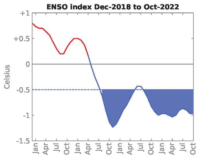
“A third consecutive La Niña was declared in spring 2022 and persisted through to early 2023. “Triple-dip” La Niña events are rare and have only happened twice since 1950, with previous events occurring in 1973-1976 and 1998-2001. Multi-year La Niña events can be associated with an increased risk of flooding due to the possibility of more rain falling on already saturated catchments.”
– Dr Zoe Gillett, Climate Change Research Centre (UNSW), ARC Centre of Excellence for Climate Extremes
Dr Kim Reid from Monash University and the ARC Centre of Excellence for Climate Extremes says if we do shift to an El Niño period, Australian communities should start preparing for bushfires.

“Now is the time to start cutting back the excess vegetation that grew over the last three years. All it takes is a dry winter and spring, which is probable with an El Niño, and all that excess vegetation will be fuel for summer bushfires.”
— Dr Kim Reid, Monash University, ARC Centre of Excellence for Climate Extremes
Professor Matthew England from the Climate Change Research Centre (UNSW) told 9Radio stations the announcement is a concerning one.
“It’s a bit worrying. Especially with this big 3 years of rain. It’s meant that a lot of forest has regrown which is fantastic, but if we then have a dry spell leading into next summer, what we don’t want to happen then is prime bushfire conditions. These La Niña and El Niño cycles, what’s bad about them, is it’s a great way to build up fuel during heavy rains and then if you have a drought it can be disastrous for bushfire seasons”
– Professor Matthew England, Climate Change Research Centre (UNSW)
Dr Tom Mortlock, Senior Analyst at Aon says the implications could be long term.
“Research by Aon and partners Climalab here suggests that the triple-dip La Niña may have tipped the Pacific ocean circulation into a long-term El Niño like state that could now persist for the coming decade. Australia’s big wet could soon become the big dry.”
Dr Tom Mortlock, Senior Analyst at Aon
Experts at the ARC Centre of Excellence for Climate Extremes will continue conducting vital research to help communities and decision makers prepare for the future.