A lingering La Niña influenced Australian rainfall for much of 2022. La Niña is an ocean temperature and wind pattern across the Pacific Ocean which pushes warm and moist air towards Australia. It therefore has an important influence on Australian rainfall, promoting increased winter-spring rainfall in eastern Australia and increased late summer-autumn rainfall along the east coast.
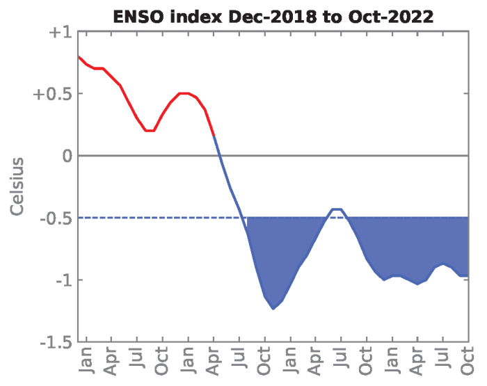
La Niña conditions first began in spring 2020 and continued until early autumn 2021. A second La Niña developed in spring 2021 and persisted through early winter 2022. Known as a “double-dip” La Niña, back-to-back Australian summers with La Niña conditions are not uncommon and have occurred in about 50% of all past La Niña events. Southeast Queensland and northeast New South Wales experienced extreme rainfall and widespread flooding in February and March 2022 towards the end of this second La Niña event. A third consecutive La Niña was declared in spring 2022 and persisted through to early 2023. “Triple-dip” La Niña events are rare and have only happened twice since 1950, with previous events occurring in 1973-1976 and 1998-2001. Multi-year La Niña events can be associated with an increased risk of flooding due to the possibility of more rain falling on already saturated catchments.
La Niña was not the only climate driver acting to promote rain across eastern Australia in 2022, particularly in spring 2022. The combined influence of a trio of rain-promoting climate drivers, La Niña, the negative phase of the Indian Ocean Dipole (IOD) and the positive phase of the Southern Annular Mode (SAM), contributed to Australia’s second wettest spring in 123 years of records.
A negative IOD is like the Indian Ocean’s version of La Niña and is associated with warmer waters around northern Australia. It promotes increased rainfall in southern and eastern Australia during winter and spring. A negative IOD event occurred from late winter to the end of spring 2022. Interestingly, this was also part of a multi-year event, after a negative IOD also occurred a year earlier in 2021.
The SAM was in its positive phase for much of spring 2022. In the positive phase of the SAM, the belt of westerly winds over the Southern Ocean moves further away from Australia. This enables more easterly winds from the Pacific Ocean to move across eastern Australia and promote increased rainfall in spring and summer.
The positive phase of the SAM also promotes reduced rainfall in parts of southern Australia, including in western Tasmania. While record-breaking rainfall in mainland eastern Australia dominated the news in 2022, in 2021/22, Tasmania had its driest summer in 41 years because the SAM was largely in its positive phase, promoting high-pressure over the state and blocking rain-producing weather systems.
The negative IOD and positive SAM tend to co-occur with La Niña and the combination of these climate drivers further increases the chances of above-average rainfall in eastern Australia.
Main research contact: Dr Zoe Gillett | zoe.gillett@unsw.edu.au
The State of Weather and Climate Extremes 2022
Weather and climate extremes in Antarctica
Extreme events in 2022
Heatwaves in Western Australia
Extreme rainfall and flooding in Queensland and New South Wales February-March 2022
Record low Antarctic sea ice extent in 2022
Simultaneous Antarctic and Arctic heatwaves
Collapse of East Antarctic Conger ice shelf
Hailstorms in Queensland, Victoria and New South Wales
Damaging wind gusts in South Australia and the Northern Territory
© 2023 ARC Centre of Excellence for Climate Extremes
References and acknowledgements available in the PDF version available here.
Materials used are for educational purposes and either author provided or used under fair dealing provisions.