Dr Kimberley Reid – ARC Centre of Excellence for Climate Extremes
Forecasting unusual weather weeks in advance is a rapidly growing area of research. It has the potential to benefit many industries from farming to energy production. Scientists at the ARC Centre of Excellence for Climate Extremes are exploring innovative methods to predict rainfall in a first of its kind pilot study.
What is Subseasonal Forecasting?
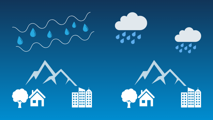
Subseasonal forecasting is the prediction of unusual weather, such as high temperature or rainfall, two to six weeks ahead. Weather is a chaotic system, sometimes acting in a similar way to the ‘butterfly effect’, where small fluctuations in wind or temperature can grow into random and big fluctuations with time.
This is why we can’t predict where a storm will be more than a few days in advance. However, we can predict whether the weekly temperature or rainfall is likely to be above or below average.
For a detailed look on the different types of modelling see here.
Why is Subseasonal Forecasting Useful?
Subseasonal forecasts are regularly used in planning. The better the forecast, the easier it is to plan. For farmers the timing of rainfall or hot days can significantly impact cultivation, crop growth, and harvesting. Forecast information is useful for timing reservoir operations or allowing water managers to time dam releases to reduce flood risks.
Higher quality forecasts would improve all these applications.
Our Study
The sporadic nature of rainfall makes it especially difficult to forecast skilfully beyond one week.
Rainfall requires two ingredients:
- moisture in the air
- and a weather system or mountain to force the moist air to rise and condense into a liquid.
In a new study, we tested a method to improve rainfall forecasts by using one of these ingredients, moisture in the air, rather than trying to predict the rainfall itself.
Integrated Water Vapour Transport (IVT), is the flow of water vapour through the atmosphere and an indication of the moisture in the air.
High amounts of water vapour transport is a strong sign of rainfall. If there is no water vapour in the air, there won’t be any rainfall.
Weather models can be used to study rainfall and are better at simulating water vapour transport than rainfall itself. This is because water vapour transport depends on larger-scale processes whereas rainfall requires small-scale processes that models may not reproduce as well.
Previous research in Europe showed that using water vapour transport to indicate extreme rainfall could extend the forecast by three days in some locations.
In our new study, we tested whether water vapour transport could be used as a proxy or substitute for forecasting rainfall up to four weeks ahead globally.
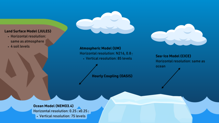
We collaborated with the Australian Bureau of Meteorology and used their latest seasonal forecasting model called ACCESS-S2 (Figure 2). We compared the forecasts of the past from 1981-2018 with satellite rainfall observations and counted how many times the modelled water vapour transport and modelled rainfall correctly identified weeks with a high certainty of rainfall.
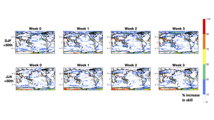
Figure 3 shows the percentage increase in the skill using water vapour transport as a proxy for rainfall compared to using the model rainfall. At one to three weeks ahead there is improved skill over large regions of Australia, the west coast of the USA and parts of Europe. These are regions where weather systems such as atmospheric rivers, fronts and extratropical cyclones, which are associated with high water vapour transport, cause a high proportion of the rainfall.
Rainfall from models is far more accurate in the first week of a forecast, but the accuracy decays rapidly. After this first week, the benefits of using rainfall ingredients instead, like IVT, may be realised.
Our new research shows that water vapour transport could be used as an indicator of a potentially wet week up to three weeks ahead.
Next Steps
More research using higher resolution modelling would be needed before this could become operational. Machine learning could help us understand the relationship between water vapour transport and the amount of rain that falls at different locations. Earlier warning of heavy rainfall would be incredibly useful to a variety of sectors.
Atmospheric Water Vapour Transport in ACCESS-S2 and the Potential for Enhancing Skill of Subseasonal Forecasts of Precipitation Kimberley J. Reid, Debra Hudson, Andrew D. King, Todd P Lane and Andrew G. Marshall.
https://rmets.onlinelibrary.wiley.com/doi/abs/10.1002/qj.4585