About this report
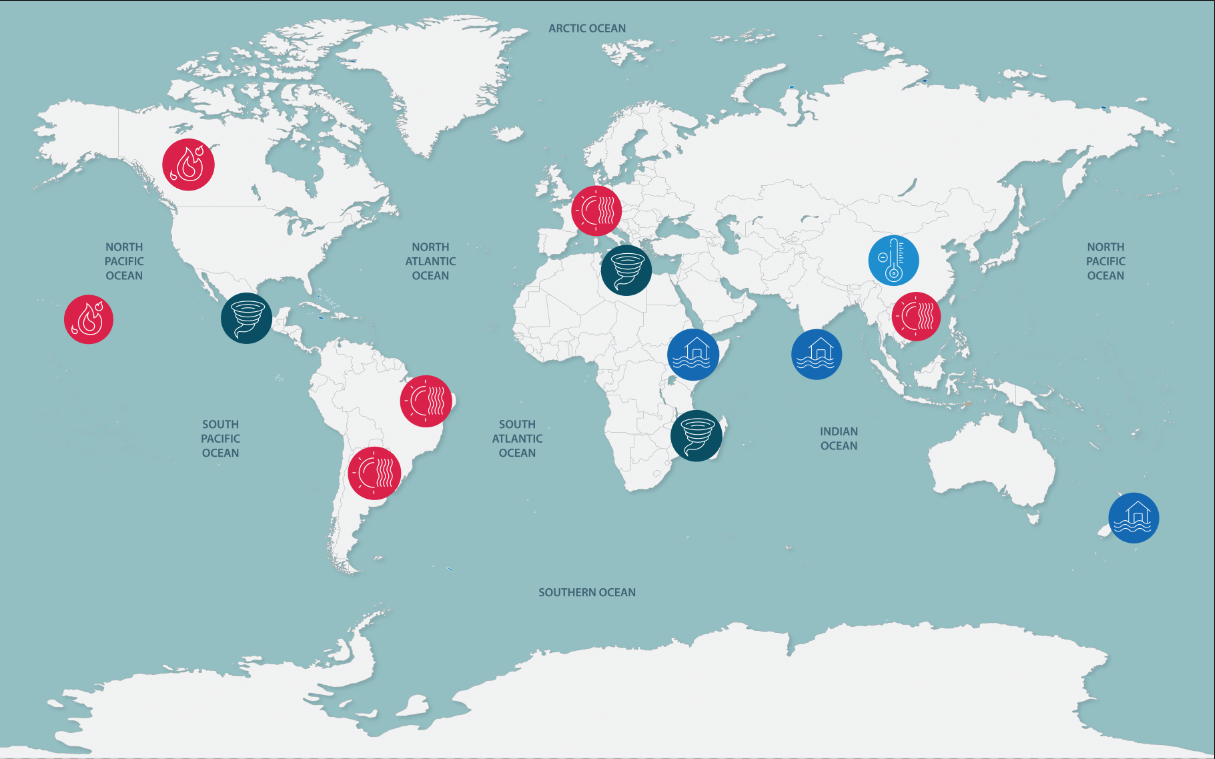
This report provides a summary of selected significant extreme weather and climate events which occurred across Australia in 2023. The report provides a description of each event and an explanation which reflects our understanding of the causes. The report also provides an overview of selected international events including Antarctica. This document has been prepared to assist policy makers and the general public understand the complexity and nature of the climate extremes we are experiencing.
Defining extreme weather and climate
The Intergovernmental Panel on Climate Change defines an extreme weather or climate event as:
‘The occurrence of a value of a weather or climate variable above (or below) a threshold value near the upper (or lower) ends of the range of observed values of the variable. By definition, the characteristics of what is called extreme weather may vary from place to place in an absolute sense. When a pattern of extreme weather persists for some time, such as a season, it may be classified as an extreme climate event, especially if it yields an average or total that is itself extreme (e.g., high temperature, drought or heavy rainfall over a season). For simplicity, both extreme weather events and extreme climate events are referred to collectively as climate extremes.’

2023 in summary
Globally, 2023 was the warmest year in recorded history.
Australia experienced a broad range of record- breaking extremes.
Impacts from extreme events had economy-wide effects.
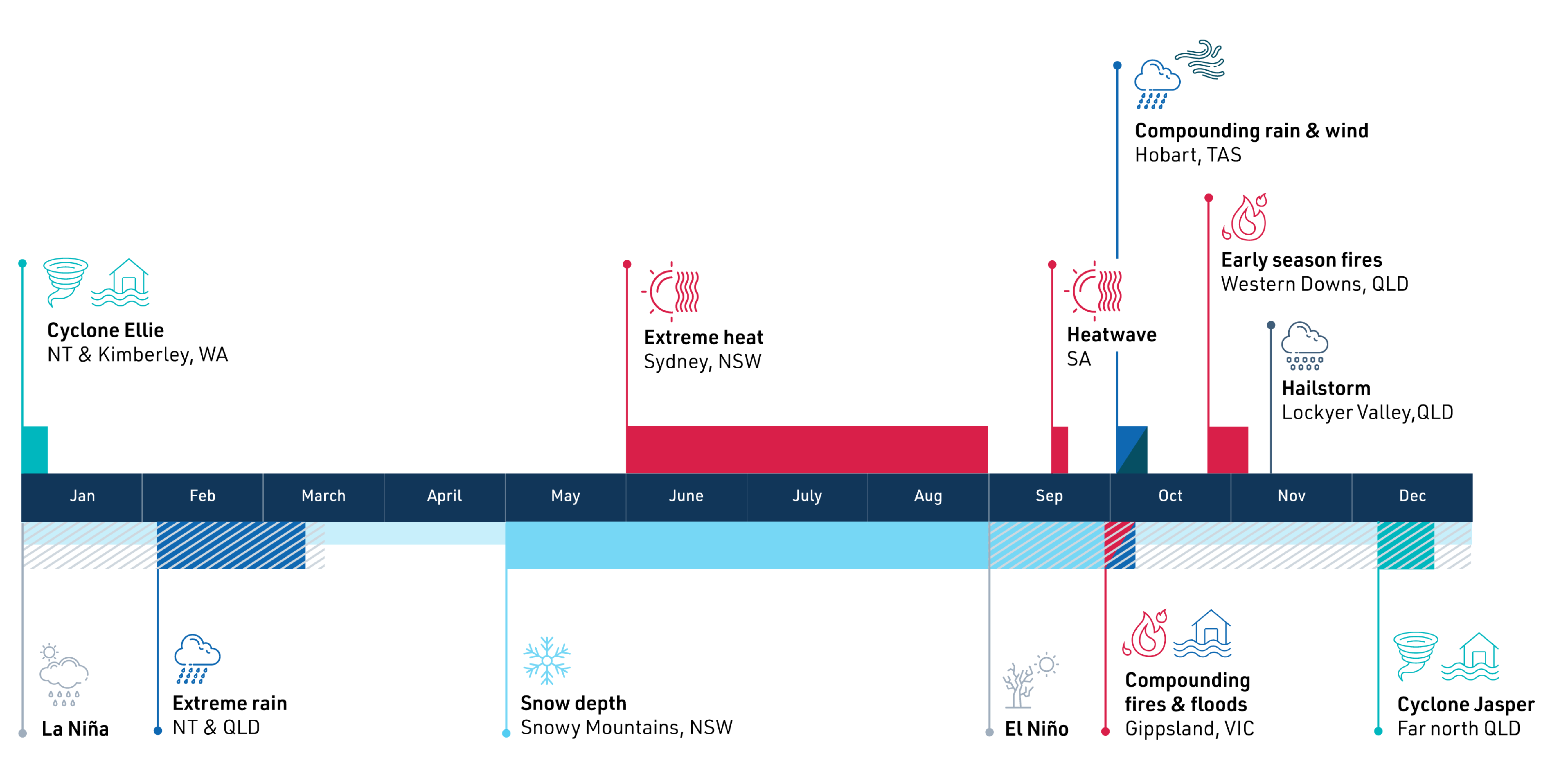
Above-average rainfall in northern Australia characterised the start of 2023, progressing to increasingly dry conditions in southern and eastern Australia as the year continued. After a multi-year La Niña, conditions returned to neutral in March; however, there were signs of an El Niño forming in the Pacific, which eventually resulted in the Bureau of Meteorology declaring an El Niño in September.
Multiple extreme events occurred across Australia, ranging from a compound fire and flood event in eastern Victoria to significant heat in eastern Australia including a record-breaking heatwave during September around the Eyre Peninsula in South Australia. Sydney and New South Wales experienced their warmest winter on record. The year concluded with Queensland bearing the brunt of multiple extreme rain events, with Cyclone Jasper and compounding severe storms causing damage and loss of life.
Climate drivers
After dominating the last three consecutive years, La Niña ended in March 2023. Neutral conditions returned before El Niño was declared in September. The positive Indian Ocean Dipole (IOD) was declared around the same time.
Temperature
Temperatures in Australia during 2023 were 0.98°C above
the 1961-1990 average, making it the eighth hottest year
on record.
Rainfall
Australia’s overall rainfall for 2023 was close to the 1961- 1990 average. The year was marked by above-average rainfall in northern Australia, while the south-eastern quarter of Queensland, significant portions of New South Wales, Tasmania and southern Western Australia experienced drier than average conditions.
Ocean
Throughout 2023 ocean temperatures were unusually hot in Australian waters. Each month of the year was ranked within the top 60% for ocean temperature. The high ocean temperatures have meant that 2023 has witnessed a concerning number of marine heatwaves
– discrete and prolonged events of extremely warm ocean temperatures.
Attributing extreme events to climate change
Australian surface air temperatures have risen by around 1.5°C, and will continue to rise until at least 2050 under all plausible emission scenarios, making further increases in some climate extremes inevitable.
Our ability to detect changes in our climate, and attribute these to human-caused climate change is very high for global scale changes in quantities like temperature, rainfall and atmospheric pressure. Detecting changes in the frequency or intensity of individual extreme events, and attributing these to human-caused climate change, is much harder and needs to be approached hazard by hazard.
Extreme events in Australia in 2023

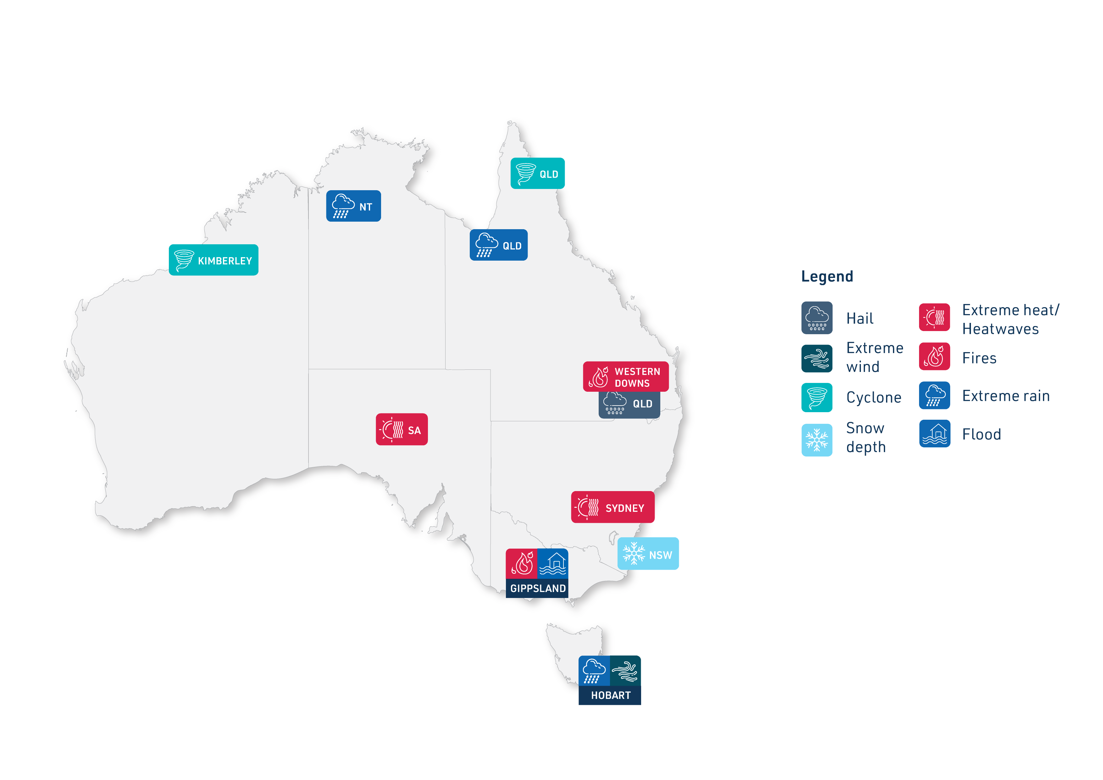
Kimberley flooding from Cyclone Ellie
- Ex-tropical Cyclone Ellie spent more than two weeks moving over the Northern Territory and Kimberley region of Western Australia.
- Ellie brought substantial rainfall and flooding to the region, with the Fitzroy River flood level exceeding the previous record by almost two metres.
- Dimond Gorge and Napier Downs received weekly rainfall totals of 830.2mm and 701.2 mm.

Flooding in Northern Territory and north-west Queensland
- A persistent low-pressure system brought extensive rainfall across wide areas of the Northern Territory and Queensland.
- Flooding occurred in remote communities, presenting a challenge for emergency services.

New South Wales winter heat
- Sydney and the state of New South Wales experienced the warmest winter on record.
- Large scale synoptic weather patterns and anthropogenic greenhouse warming were major driving factors.
- The heat and rainfall deficits during winter accelerated the early onset of the bushfire season in the state.

Early end to snow season in the Australian Alps
- The Australian Alps experienced rapid and early loss of snow cover in September of the 2023 snowsports season.
- The unusually warm and dry weather from June to September contributed to the snow loss.

South Australia September heatwave
- A record-breaking heatwave occurred throughout mid-September around the Eyre Peninsula.
- Some areas reached temperatures over 18°C above average.

Gippsland fires and floods
- Gippsland experienced unseasonably early spring bushfires.
- A strong cut-off low extinguished the fires but caused widespread flooding.
- Centre research is trying to understand how these weather features may behave in the future.

Early season Queensland bushfires
- Queensland experienced over 1000 bushfires in late October 2023.
- The Western Downs region in south-east Queensland was significantly impacted, with the town of Tara losing more than 20,000 hectares of land to the fires.

Compound rain-wind event in Hobart
- A slow-moving low-pressure system brought heavy rain to Tasmania, dumping a month’s worth of rain over a large part of the island.
- This was followed by another low-pressure system associated with extreme winds two days later.

Lockyer Valley hailstorm
- A severe thunderstorm brought hail and extreme wind gusts to south-east Queensland’s Lockyer Valley on 10th November 2023.
- The storm resulted in one fatality and destroyed crops and farm equipment with an estimated loss of $50 million.

Cyclone Jasper in Queensland
- Tropical Cyclone Jasper made landfall north of Cairns on 13th December bringing strong winds, significant rainfall and flooding.
- Jasper stalled as a weak tropical low over Cape York, contributing further rainfall and flooding over far north Queensland.
- Jasper caused evacuations, power outages, disruption of supply chains and damage to tourism and agriculture.

Record-low Antarctic sea ice
- Both the southern hemisphere summer (2022/23) and winter (2023) sea ice extent were at a record low.
- The winter sea ice maximum extent was over 1 million square kilometres less than the previous record.
- The very low Antarctic sea ice extent throughout 2023 is unmatched in historical observations.

Download this report
This report is also available as a PDF.
To contact us about the report, email clex@unsw.edu.au
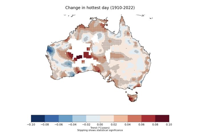
Trends over Australia
Climate extremes are changing fast and it’s hard to keep on top of those changes. Developed by the ARC Centre of Excellence for Climate Extremes, a new climate dashboard provides the ability to examine trends of climate extremes using additional indicators of extremes. The climate dashboard (https://www.climdex.org/dashboard/) enables easy and reliable access to data. Examining temperature and rainfall extremes can be challenging.
Extreme events around the world
Globally, 2023 was a year of extremes. We present a selection of extreme events from around the world.
