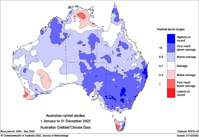
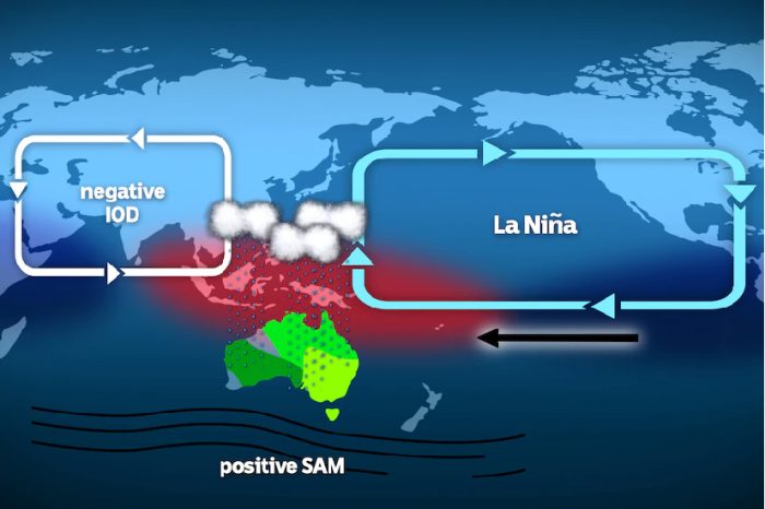
Much of Australia experienced above average rainfall for 2022, as the second La Niña transitioned to a third consecutive La Niña accompanied by wet phase climate drivers: a negative Indian Ocean Dipole (IOD) and a predominantly positive Southern Annular Mode (SAM). The occurrence of three consecutive La Niña events is rare, but not unprecedented, having occurred previously in 1973-1976 and 1998-2001. A second La Niña peaked at the beginning of 2022, with flooding returning and affecting south-eastern Queensland and eastern New South Wales from late February 2022. Storms saw areas of south-eastern Queensland and eastern New South Wales receive rainfall over 5 times the February average. The extreme rain brought floods to many areas, with Lismore recording flood levels 2m higher than previous records.
By the end of the first week of March, both Queensland and New South Wales had received more than a year’s worth of rain in a month. Further storms continued to hit these regions over following months, causing repeated flooding.
By autumn, La Niña weakened returning to a neutral phase, although four out of seven forecasting models were predicting La Niña would return in late spring or summer of 2022. The heavy rain continued in winter. For Greater Sydney, July was the wettest on record with areas receiving up to 8 times their average rainfall for the month. This caused major flooding and the evacuation of 85,000 people. July was also very wet for Queensland with many sites in the east of the state recording their wettest July. From late winter until the end of spring, the Indian Ocean Dipole was in its negative phase. In September, the Bureau of Meteorology declared a third La Niña in a row. This was coupled with a positive Southern Annular Mode for much of spring making an extremely wet spring.
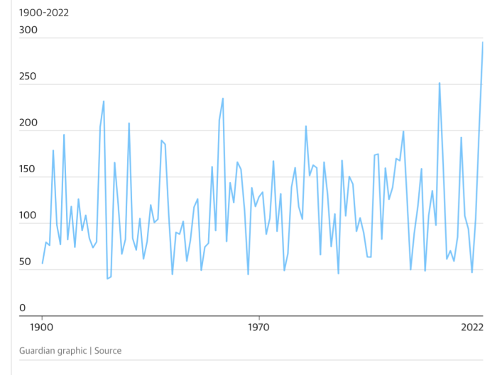
Spring rainfall in 2022 was 112% above average for Australia, the second wettest spring on record. The Murray-Darling Basin saw its wettest spring on record breaking the previous spring record of 251mm with just over 295mm. The Murray-Darling Basin October record was also broken. The Hume Dam, in southern New South Wales, which supplies a large amount of water to the Murray-Darling Basin, had its largest rainfall on record.
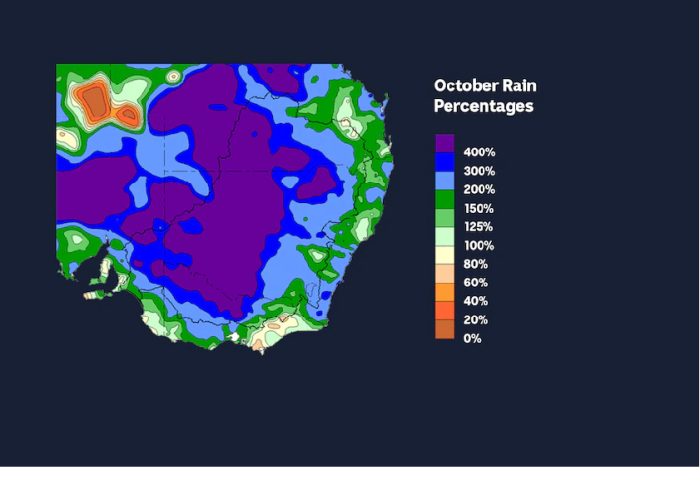
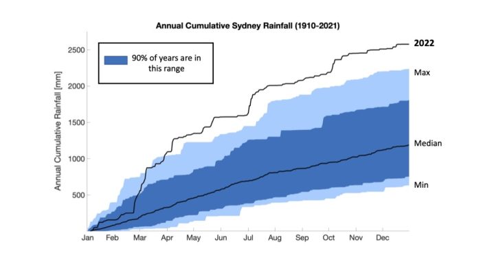
October was the second wettest on record for Australia as a whole. Many rain gauge stations in New South Wales, Victoria and Tasmania had their wettest October on record. In Echuca, the Murray River reached 94.98m in October, the highest level in 29 years. Many regions in northern Tasmania, including Sheffield and Deloraine had their wettest October on record. Heavy rainfall from the 12th-14th of October, brought flooding to parts of northern Tasmania. By early October, Sydney had broken its record for wettest year ever, with a total of 2522.8mm of rainfall for 2022. This beats the previous annual record of 2194 mm from 1950 and was double the city’s annual average of 1213.4 mm.
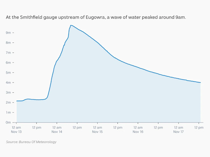
November in south-eastern Australia was amongst the top 3 wettest Novembers on record. On the 13th of November in northern Victoria, Seymour flood levels exceeded the record of 7.64m set in 1974 to 8.37m. A day later on the 14th of November, the town of Eugowra in the central west of New South Wales experienced flash flooding or an ‘inland tsunami’. Water levels in Eugowra peaked at 11.2 m, shattering the previous record of 10.01m in 1950.
As of December 26, Brisbane was just 26mm away from exceeding its 1972 record. The Alderley rain gauge, in Brisbane’s north, received more than 45 per cent of its total 2022 rainfall in just one week at the end of February.
The State of Weather and Climate Extremes 2022
Weather and climate extremes in Antarctica
Extreme events in 2022
Heatwaves in Western Australia
Extreme rainfall and flooding in Queensland and New South Wales February-March 2022
Record low Antarctic sea ice extent in 2022
Simultaneous Antarctic and Arctic heatwaves
Collapse of East Antarctic Conger ice shelf
Hailstorms in Queensland, Victoria and New South Wales
Damaging wind gusts in South Australia and the Northern Territory
© 2023 ARC Centre of Excellence for Climate Extremes
References and acknowledgements available in the PDF version available here.
Materials used are for educational purposes and either author provided or used under fair dealing provisions.