- Sydney experienced its wettest year on record in 2022.
- Three weather events were responsible for 40% of the total rainfall in 2022.
Sydney experienced its wettest year on record in 2022. This record-breaking year was a result of just three main rainfall events in February – March, July and October. Sydney (Observatory Hill) received 2530 mm of rainfall in 2022 which is more than double the average Sydney rainfall (1213 mm).
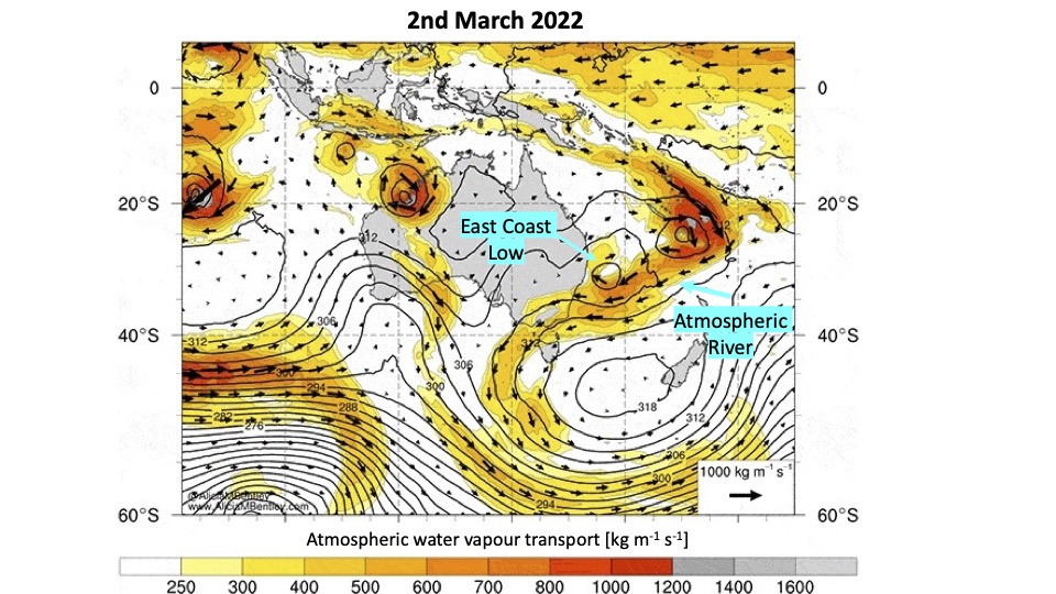
Atmospheric rivers played an important role in these heavy rainfall events, providing the large source of moisture which was dumped over Sydney. Atmospheric rivers are narrow regions of enhanced water vapour transport in the lower atmosphere and are often associated with extreme rainfall over Eastern Australia. Atmospheric rivers feed huge amounts of water into other weather features such as low-pressure systems and cold fronts, which then convert the water vapour into rainfall via uplift – the process of forcing air to rise and cool where it can then condense into rainfall. During the February – March heavy rainfall, an atmospheric river from the warm Coral Sea fed moisture into an east coast low, which dumped this moisture over Sydney.
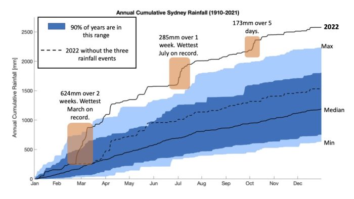
East coast lows are strong low-pressure systems that move along the east coast of Australia powered by the warm East Australian Current that runs parallel to the coast. Similarly, in July, a Low became cut-off from the steering westerly winds to the south of Australia and sat over NSW. This Low was also fed by an atmospheric river over the Coral Sea and dumped 285mm over Sydney in one week. In October, the rainfall came from the west with the passage of multiple fronts and associated atmospheric rivers. Atmospheric rivers over the Coral Sea are more likely during La Niña periods while east coast lows have a weak relationship with El Niño and La Niña.
The heavy rainfall events in February-March and July caused flash flooding across Sydney and significant flooding of the Hawkesbury-Nepean catchment. During the July storms, millions of people in the Greater Sydney region were advised to stay home and avoid any non-essential travel due to trains being significantly impacted. Fifty thousand people were affected by evacuation orders and warnings and the State Emergency Service received more than 5,300 requests for assistance, of which over 250 were flood rescues.
Recent research at the ARC Centre of Excellence for Climate Extremes indicates that the intensity of short duration (sub-hourly) rainfall events have already intensified over the past two decades, at least over the Sydney Basin. However, how longer duration rainfall events will change in the future is still an active topic of research.
Main research contact: Dr Kim Reid | kim.reid@monash.edu
The State of Weather and Climate Extremes 2022
Weather and climate extremes in Antarctica
Extreme events in 2022
Heatwaves in Western Australia
Extreme rainfall and flooding in Queensland and New South Wales February-March 2022
Record low Antarctic sea ice extent in 2022
Simultaneous Antarctic and Arctic heatwaves
Collapse of East Antarctic Conger ice shelf
Hailstorms in Queensland, Victoria and New South Wales
Damaging wind gusts in South Australia and the Northern Territory
© 2023 ARC Centre of Excellence for Climate Extremes
References and acknowledgements available in the PDF version available here.
Materials used are for educational purposes and either author provided or used under fair dealing provisions.