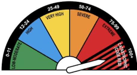
Have you ever seen a sign displaying the risk of fire weather conditions for the day? This sign shows the Forest Fire Danger Index, which indicates the probability of fire weather.
Key takeaways:
- There are large uncertainties around how atmospheric processes contribute to fire events.
- Existing methods and observational datasets are limited and cannot explain these atmospheric processes.
- High resolution simulations of the atmosphere allow researchers to address some of these limitations.
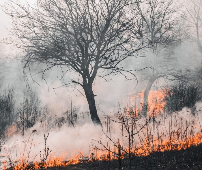
Wildfire is a natural disaster with major destructive impacts. They are complex events and our understanding of the factors which form and intensify major fire events is limited. Multiple atmospheric factors increase the likelihood and intensity of fires. These include:
- high temperatures and very low humidities, especially during heatwaves,
- dry vegetation, which provides fuel but also the risk of fire being sustained once ignited,
- strong winds, which intensify and change the direction of a fire.
A critical component of fire is exactly how dry air is transported from locations surrounding the fire. This transport of air occurs through a wide range of large and small-scale atmospheric processes. (Australian Meteorological Magazine – December 2008) There is a lack of knowledge in understanding the processes that control this flow of dry air, and how it mixes with the air where the fire is occurring. Very high-resolution atmospheric modelling is an essential tool to help increase our understanding and our ability to predict fire behaviour. These predictions are, in turn, central to helping us prepare, and protect life and infrastructure.
Existing methods in studying fire weather
One useful method of identifying and predicting fire risk over a region is via measuring or predicting atmospheric quantities such as temperature, humidity, and wind magnitude/direction. Using a combination of these variables, indices such as the “Forest Fire Danger Index (FFDI)” can be calculated, which range from 0 (no risk) to over 100 (catastrophic risk). FFDI is commonly used in Australia to assess the degree of fire danger.
However, this method has large uncertainties in terms of predicting the timing and the location of the fire in part because this method doesn’t consider the transportation of dry air through the atmosphere via large- and small-scale processes.
Using models to understand dry air transportation
Global climate models are designed to simulate the Earth’s climate and these models are impressive at large spatial scales. They can be used to simulate the atmosphere and can be extremely detailed, but they tend to be quite coarse resolution. This means they cannot simulate the weather patterns that are linked with catastrophic fire risk.
Regional climate models can simulate the atmosphere with a higher resolution over a specific area. They can simulate regions with a grid size of around 10-50km. While they provide more details about the atmosphere compared to global climate models, their resolutions are still too coarse to capture smaller-scale processes (especially in the planetary boundary layer) that play important roles in fire weather.
Convection-permitting models simulate the atmosphere with very high resolutions (kilometre-scale grid spacing) to address this issue, but they are expensive to run over a large domain or area. Therefore, most studies that use these models are focused on a very small region (e.g., a single city) which limits our ability to study large-scale processes.
Resolving the challenge of requiring very high resolution to represent processes, and at the same time simulating reasonably large regions, has been impossible in the past. However, thanks to recent advances in supercomputing, it has recently become possible to run these very high-resolution models over large regions (as large as Australia). This has provided the tools that give us a chance to understand the large- and small-scale processes, and the interactions between these processes. This provides us with a better understanding of how the atmosphere influences fire behavior.
There are different atmosphere models that are developed by different organisations across the world and can be used for this type of study. We use the “Unified Model”. Originally developed by the UK Met Office, the Unified Model is a world-leading atmosphere model that can be used for both weather and climate applications. In Australia, the operational weather models used by the Bureau of Meteorology is based on the Unified Model. The Unified Model is also becoming one of the main atmospheric models used by the research community across Australia.
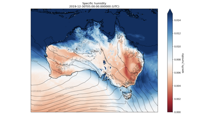
Figure 1: Surface specific humidity derived from the high-resolution simulations on 30th Dec 2019 at 3:00 pm AEST. The red band over the eastern Australia is probably influential in how the fires that occurred in this region behaved.
Using the Unified Model to understand Black Summer
We used the Unified Model to simulate one of the black summer events that occurred over the end of 2019 and beginning of 2020. It focusses on the period from 8pm on 29 December 2019 to midnight on 2 January 2020. The project is researching both small and large-scale atmospheric processes, at a very high resolution – 2.2km. This allows us to look at processes which occur across a continental scale, the entirety of Australia. This high-resolution model uses part of the Aus2200 project looking at 3 days i.e., the study period for this fire event.
Figure 1 shows the specific humidity across Australia during the analysis period. Research is being undertaken to determine how this contributed to the start of fire activities in the Blue Mountains’ forests in NSW and northern Victoria.
This simulation stores 8 terabytes of data on the National Computing Infrastructure outputting atmospheric variables such as temperature, humidity and precipitation over a region of 2120 (length) x 2600 (width) x70 (height) grids every hour. That is a lot of data! The process is optimised to try and use the minimum resources.
Further research will look at the dynamics of how the humidity is decreasing over the region and what this can tell us about the conditions suitable for fires to begin.
These are valuable simulations and help us to understand how the atmospheric processes are contributing to fire risk. This project is part of the weather and climate interactions research program of the ARC Centre of Excellence for Climate Extremes.